
Istarska županija topographic map
Interactive map
Click on the map to display elevation.
Istarska županija
The terrain consists of a limestone plateau much of which lacks water owing to its karst topography. The northeastern section is an extension of the Dinaric Alps. The highest point is Vojak on Učka mountain 1,401 m (4,596.46 ft) above sea level and there is another range of mountains, the Ćićarija.
About this map
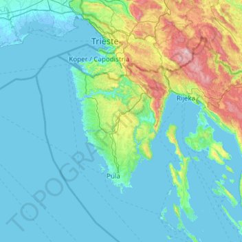
Name: Istarska županija topographic map, elevation, terrain.
Location: Istarska županija, Istria County, Croatia (44.48548 13.20903 45.88548 14.60903)
Average elevation: 187 m
Minimum elevation: -5 m
Maximum elevation: 1,755 m
Other topographic maps
Click on a map to view its topography, its elevation and its terrain.
Krk
Croatia > Primorje-Gorski Kotar County
A Eurasian griffon vulture colony lives in protected in an area called Kuntrep on Krk., There they breed at low elevations, with some nests at 10 m (33 ft). Therefore, contact with people is common.
Average elevation: 95 m
Plitvice Lakes National Park
Croatia > Lika-Senj County > Plitvički Ljeskovac
The 16 lakes are separated into an upper and lower cluster formed by runoff from the mountains, descending from an altitude of 636 to 503 m (2,087 to 1,650 ft) over a distance of some 8 kilometres (5.0 mi), aligned in a south–north direction. The lakes collectively cover an area of about 0.77 square miles,…
Average elevation: 765 m
Grad Sisak
Croatia > Sisak-Moslavina County
Sisak (pronounced [sǐːsak]; also known by other alternative names) is a city in central Croatia, spanning the confluence of the Kupa, Sava and Odra rivers, 57 km (35 mi) southeast of the Croatian capital Zagreb, and is usually considered to be where the Posavina (Sava basin) begins, with an elevation of 99…
Average elevation: 132 m
Grad Požega
Croatia > Požega-Slavonia County
Požega (elevation: 152 m (499 ft)) is located in the south-western part of the Valley of Požega, or Požega basin, in Croatian: Požeška kotlina. This fertile valley has been important since the antiquity - its Roman name was Vallis Aurea, meaning "golden valley".
Average elevation: 222 m
Osijek
Osijek (Croatian pronunciation: (listen)) is the fourth largest city in Croatia with a population of 108,048 in 2011. It is the largest city and the economic and cultural centre of the eastern Croatian region of Slavonia, as well as the administrative centre of Osijek-Baranja County. Osijek is located on the…
Average elevation: 87 m