
Make a donation
West Pokot topographic map
Click on the map to display elevation.
Make a donation
About this map
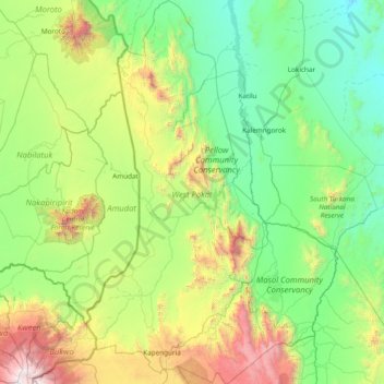
Name: West Pokot topographic map, elevation, terrain.
Location: West Pokot, Rift Valley, Kenya (1.12564 34.78710 2.65026 35.79090)
Average elevation: 1,290 m
Minimum elevation: 554 m
Maximum elevation: 4,170 m
Make a donation
Other topographic maps
Click on a map to view its topography, its elevation and its terrain.
Nyahururu
Kenya > Laikipia County > Laikipia West
Nyahururu is also frequented by marathon and cross-country runners for practicing before major events due to its high altitude.
Average elevation: 2,348 m
Make a donation
Make a donation
Eldoret
Kenya > Uasin Gishu County > Moiben
Eldoret is a city in the Rift Valley region of Kenya. It serves as the capital of Uasin Gishu County. Located in western Kenya, and lying south of the Cherangani Hills, the local elevation varies from about 2,100 metres (6,900 ft) at the airport to more than 2,700 metres (8,900 ft) in nearby areas.
Average elevation: 2,093 m
Make a donation
Make a donation
Make a donation
Make a donation