
Make a donation
Bacoor topographic map
Click on the map to display elevation.
Make a donation
About this map
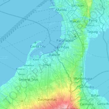
Name: Bacoor topographic map, elevation, terrain.
Location: Bacoor, Cavite, Calabarzon, Philippines (14.29882 120.79958 14.61882 121.11958)
Average elevation: 18 m
Minimum elevation: -3 m
Maximum elevation: 172 m
Make a donation
Other topographic maps
Click on a map to view its topography, its elevation and its terrain.
Mounts Palay-Palay–Mataas-na-Gulod Protected Landscape
Philippines > Cavite > Ternate
A 38.3 kilometres (23.8 mi) trail traversing the mountains of the protected landscape has been mapped and established by a five-man expedition team in 2014, to which the trail starts at Barangay Ramirez of Magallanes, Cavite passing through Mataas na Gulod, Dos Picos, Kalanggaman, and ends at Mount Palay-Palay…
Average elevation: 206 m
Corregidor Island
Philippines > Cavite > Cavite City
The tadpole-shaped island, with its tail running eastward, is about 6.5 km (4.0 mi) long, about 2.0 km (1.2 mi) wide at its widest with a total land area of about 900 hectares (2,200 acres). The highest elevation is at 180 m (590 ft) on the Topside. The island is divided into four sections.
Average elevation: 11 m
Make a donation
Make a donation
Make a donation
Make a donation
Make a donation
Make a donation
Make a donation
Make a donation