
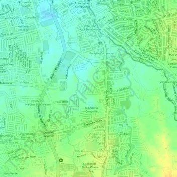
Villa Antonina Subdivision topographic map
Interactive map
Click on the map to display elevation.
About this map
Name: Villa Antonina Subdivision topographic map, elevation, terrain.
Location: Villa Antonina Subdivision, Cavite, Calabarzon, Philippines (14.42968 120.97039 14.43186 120.97360)
Average elevation: 16 m
Minimum elevation: 4 m
Maximum elevation: 30 m
Other topographic maps
Click on a map to view its topography, its elevation and its terrain.
Palocpoc II
Philippines > Cavite > Mendez
Palocpoc II, Mendez, Cavite, Calabarzon, 4121, Philippines
Average elevation: 465 m
General Trias
General Trias, Cavite, Calabarzon, 4107, Philippines
Average elevation: 85 m
Tagaytay
Philippines > Cavite > Tagaytay > Tagaytay
Tagaytay, Cavite, Calabarzon, 4120, Philippines
Average elevation: 229 m
Palocpoc I
Philippines > Cavite > Mendez
Palocpoc I, Mendez, Cavite, Calabarzon, 4121, Philippines
Average elevation: 481 m
Bagong Bayan
Philippines > Cavite > Dasmariñas
Bagong Bayan, Dasmariñas, Cavite, Calabarzon, Philippines
Average elevation: 105 m
Bagtas
Philippines > Cavite > Tanza
Bagtas, Tanza, Cavite, Calabarzon, 4108, Philippines
Average elevation: 43 m
Bucal I
Philippines > Cavite > Maragondon
Bucal I, Maragondon, Cavite, Calabarzon, 4112, Philippines
Average elevation: 24 m
Paliparan 1
Philippines > Cavite > Dasmariñas
Paliparan 1, Paliparan, Dasmariñas, Cavite, Calabarzon, 4114, Philippines
Average elevation: 193 m
Luksuhin Ilaya
Philippines > Cavite > Alfonso
Luksuhin Ilaya, Alfonso, Cavite, Calabarzon, 4123, Philippines
Average elevation: 511 m
Pantihan IV
Philippines > Cavite > Maragondon
Pantihan IV, Maragondon, Cavite, Calabarzon, 4112, Philippines
Average elevation: 207 m
Luksuhin Ibaba
Philippines > Cavite > Alfonso
Luksuhin Ibaba, Alfonso, Cavite, Calabarzon, 4123, Philippines
Average elevation: 538 m
Halang
Philippines > Cavite > Amadeo
Halang, Amadeo, Cavite, Calabarzon, 4119, Philippines
Average elevation: 335 m
Aguado
Philippines > Cavite > Trece Martires
Aguado, Trece Martires, Cavite, Calabarzon, 4109, Philippines
Average elevation: 156 m
Asisan
Philippines > Cavite > Tagaytay
Asisan, Tagaytay, Cavite, Calabarzon, 4120, Philippines
Average elevation: 526 m
Talon
Philippines > Cavite > Amadeo
Talon, Amadeo, Cavite, Calabarzon, 4119, Philippines
Average elevation: 533 m
Halang
Philippines > Cavite > Naic
Halang, Naic, Cavite, Calabarzon, 4110, Philippines
Average elevation: 44 m
Taywanak Ilaya
Philippines > Cavite > Alfonso
Taywanak Ilaya, Alfonso, Cavite, Calabarzon, 4123, Philippines
Average elevation: 334 m
Tua
Philippines > Cavite > Magallanes
Tua, Magallanes, Cavite, Calabarzon, 4113, Philippines
Average elevation: 269 m
Purok 1
Philippines > Cavite > Silang > Hukay
Purok 1, Hukay, Silang, Cavite, Calabarzon, 4118, Philippines
Average elevation: 253 m
Metrogate Dasmariñas
Philippines > Cavite > Dasmariñas
Metrogate Dasmariñas, San Agustin 1, San Agustin, Dasmariñas, Cavite, Calabarzon, 4114, Philippines
Average elevation: 123 m
Florida Sun Estates
Florida Sun Estates, Cavite, Calabarzon, Philippines
Average elevation: 127 m
Maitim 2nd Central
Philippines > Cavite > Tagaytay
Maitim 2nd Central, Tagaytay, Cavite, Calabarzon, 4120, Philippines
Average elevation: 561 m
Lapu-lapu
Philippines > Cavite > Cavite City
Lapu-lapu, Cavite City, Cavite, Calabarzon, 4100, Philippines
Average elevation: 2 m
Caluangan
Philippines > Cavite > Magallanes
Caluangan, Magallanes, Cavite, Calabarzon, 4113, Philippines
Average elevation: 219 m
Zapote River
Philippines > Cavite > Las Piñas
Zapote River, Talon Singko, 2nd District, Las Piñas, Southern Manila District, Cavite, Metro Manila, 1741, Philippines
Average elevation: 28 m
Lumil
Philippines > Cavite > Silang
Lumil, Silang, Cavite, Calabarzon, 4118, Philippines
Average elevation: 374 m
Pasong Camachile II
Philippines > Cavite > General Trias
Pasong Camachile II, General Trias, Cavite, Calabarzon, 4107, Philippines
Average elevation: 37 m
Buenavista II
Philippines > Cavite > General Trias
Buenavista II, General Trias, Cavite, Calabarzon, 4107, Philippines
Average elevation: 83 m
Kaytitinga III
Philippines > Cavite > Alfonso
Kaytitinga III, Alfonso, Cavite, Calabarzon, 4123, Philippines
Average elevation: 451 m
Santa Cruz
Philippines > Cavite > Tanza
Santa Cruz, Tanza, Cavite, Calabarzon, 4108, Philippines
Average elevation: 12 m
Malabag
Philippines > Cavite > Silang
Malabag, Silang, Cavite, Calabarzon, 4118, Philippines
Average elevation: 520 m
Amuyong
Philippines > Cavite > Alfonso
Amuyong, Alfonso, Cavite, Calabarzon, 4123, Philippines
Average elevation: 529 m
Bagong Tubig
Philippines > Cavite > Tagaytay
Bagong Tubig, Tagaytay, Cavite, Calabarzon, 4120, Philippines
Average elevation: 396 m
Buenavista I
Philippines > Cavite > General Trias
Buenavista I, General Trias, Cavite, Calabarzon, 4107, Philippines
Average elevation: 69 m
San Vicente I
Philippines > Cavite > Silang
San Vicente I, Silang, Cavite, Calabarzon, 4118, Philippines
Average elevation: 306 m
Calabuso
Philippines > Cavite > Tagaytay
Calabuso, Tagaytay, Cavite, Calabarzon, 4120, Philippines
Average elevation: 413 m
Alapan II-B
Philippines > Cavite > Imus
Alapan II-B, Imus, Cavite, Calabarzon, 4103, Philippines
Average elevation: 20 m
Kalubkob
Philippines > Cavite > Silang
Kalubkob, Silang, Cavite, Calabarzon, 4118, Philippines
Average elevation: 340 m
General Trias
General Trias, Cavite, Calabarzon, Philippines
Average elevation: 47 m
Chester Place
Philippines > Cavite > Dasmariñas
Chester Place, Burol, Dasmariñas, Cavite, Calabarzon, 4114, Philippines
Average elevation: 86 m
Panungyanan
Philippines > Cavite > General Trias
Panungyanan, General Trias, Cavite, Calabarzon, 4107, Philippines
Average elevation: 252 m
Woodsite 1
Philippines > Cavite > Imus
Woodsite 1, Pasong Buaya II, Imus, Cavite, Calabarzon, 4103, Philippines
Average elevation: 38 m
Tubuan II
Philippines > Cavite > Silang
Tubuan II, Silang, Cavite, Calabarzon, 4118, Philippines
Average elevation: 330 m
Mount Sungay
Philippines > Cavite > Tagaytay > Iruhin South
Mount Sungay, Iruhin South, Tagaytay, Cavite, Calabarzon, 4120, Philippines
Average elevation: 501 m
Precious Ville
Philippines > Cavite > Naic > Gomez-Zamora
Precious Ville, Gomez-Zamora, Naic, Cavite, Calabarzon, 4110, Philippines
Average elevation: 10 m