
Thank you for supporting this site ❤️
Make a donation
Make a donation
Mount Mataba topographic map
Click on the map to display elevation.
Thank you for supporting this site ❤️
Make a donation
Make a donation
About this map
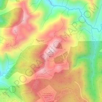
Name: Mount Mataba topographic map, elevation, terrain.
Location: Mount Mataba, Rizal, Calabarzon, 1050, Philippines (14.69328 121.16384 14.69338 121.16394)
Average elevation: 279 m
Minimum elevation: 72 m
Maximum elevation: 435 m
Thank you for supporting this site ❤️
Make a donation
Make a donation
Other topographic maps
Click on a map to view its topography, its elevation and its terrain.
Thank you for supporting this site ❤️
Make a donation
Make a donation
Thank you for supporting this site ❤️
Make a donation
Make a donation
Thank you for supporting this site ❤️
Make a donation
Make a donation