
Make a donation
Selkirk topographic map
Click on the map to display elevation.
Make a donation
About this map
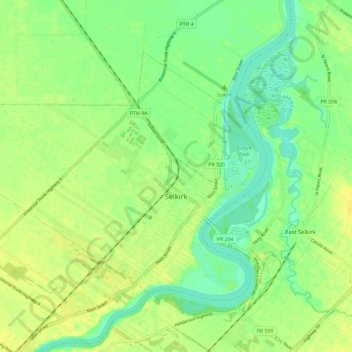
Name: Selkirk topographic map, elevation, terrain.
Location: Selkirk, Manitoba, Canada (50.12485 -96.96682 50.17761 -96.85023)
Average elevation: 227 m
Minimum elevation: 217 m
Maximum elevation: 236 m
Make a donation
Other topographic maps
Click on a map to view its topography, its elevation and its terrain.
Courtenay
Canada > British Columbia > Comox Valley Regional District > Courtenay
Average elevation: 187 m
Nelson
Canada > British Columbia > Regional District of Central Kootenay > Nelson
Average elevation: 1,422 m
Make a donation
Rubble Creek
Canada > British Columbia > Squamish-Lillooet Regional District > Area D (Elaho/Garibaldi)
Average elevation: 787 m
Make a donation
Nemaiah Valley
Canada > British Columbia > Cariboo Regional District > Area J (West Chilcotin)
Average elevation: 1,270 m
Make a donation
Stoney Creek
Canada > British Columbia > Regional District of Central Kootenay > Area K (The Arrow Lakes)
Average elevation: 1,295 m
Coyle Park
Canada > British Columbia > Regional District of Fraser-Fort George > Prince George
Average elevation: 625 m
Make a donation
Muskwa River
Canada > British Columbia > Peace River Regional District > Area B (Finlay Valley/Beatton Valley)
Average elevation: 1,496 m
Annapolis Valley
Canada > Nova Scotia > Municipality of the County of Kings > Auburn
Average elevation: 77 m
Make a donation
Make a donation
Mount Albert
Canada > British Columbia > Sunshine Coast Regional District > Area A (Egmont/Pender Harbour)
Average elevation: 1,937 m
Havre-Aubert
Canada > Urban agglomeration of Les Îles-de-la-Madeleine > Les Îles-de-la-Madeleine
Average elevation: 3 m
Make a donation
Make a donation
Lyell Creek
Canada > British Columbia > Columbia-Shuswap Regional District > Area A (Kicking Horse/Kinbasket Lake)
Average elevation: 1,323 m
Make a donation
Appledale
Canada > British Columbia > Regional District of Central Kootenay > Area H (The Slocan Valley)
Average elevation: 707 m
Make a donation
Mink Lake
Canada > British Columbia > Regional District of Bulkley-Nechako > Area E (Ootsa Lake/François Lake)
Average elevation: 898 m
Mount Hobson
Canada > British Columbia > Regional District of Bulkley-Nechako > Area D (Endako/Fort Fraser)
Average elevation: 1,079 m
Make a donation
Make a donation
Area G (Forster Creek/Mount Assiniboine)
Canada > British Columbia > Regional District of East Kootenay
Average elevation: 2,710 m
Make a donation
Garden Bay
Canada > British Columbia > Sunshine Coast Regional District > Area A (Egmont/Pender Harbour)
Average elevation: 79 m
Make a donation
Salmon Valley
Canada > British Columbia > Regional District of Fraser-Fort George > Area A (Salmon River/Lakes) > Salmon Valley
Average elevation: 649 m
Millbrook
Canada > Ontario > Peterborough County > Cavan-Monaghan
Peterborough's topography is largely defined by land formations created by the receding Wisconsian glaciers 10,000–15,000 years ago. The South End and Downtown portions of the city sit on what was the bottom of the glacial Lake Peterborough—part of a glacial spillway created when glacial meltwaters from…
Average elevation: 250 m
Make a donation
MacTier
Canada > Ontario > Muskoka District > Georgian Bay Township > MacTier
Average elevation: 241 m
Make a donation
Whistler Village
Canada > British Columbia > Squamish-Lillooet Regional District > Whistler Resort Municipality > Whistler Village
Average elevation: 775 m
Make a donation
Fanny Bay
Canada > British Columbia > Comox Valley Regional District > Area A (Baynes Sound) > Fanny Bay
Average elevation: 36 m
Union Bay
Canada > British Columbia > Comox Valley Regional District > Area A (Baynes Sound) > Union Bay
Average elevation: 39 m
Tsable River
Canada > British Columbia > Comox Valley Regional District > Area A (Baynes Sound)
Average elevation: 493 m
Make a donation
Rivervale
Canada > British Columbia > Regional District of Kootenay Boundary > Area B (Lower Columbia/Old Glory)
Average elevation: 610 m
Make a donation
Anse à Digue
Canada > Nova Scotia > Municipality of the County of Inverness > Chéticamp Island
Average elevation: 12 m
Middle Hill
Canada > British Columbia > North Coast Regional District > Area D (Graham Island)
Average elevation: 248 m
Make a donation
Glacier Bay
Canada > British Columbia > Area F (McConnell Creek/Hatzic Prairie)
Average elevation: 189 m