
Polkville topographic map
Interactive map
Click on the map to display elevation.
About this map
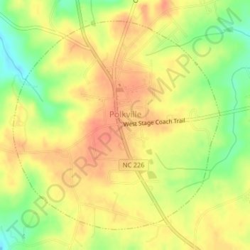
Name: Polkville topographic map, elevation, terrain.
Average elevation: 316 m
Minimum elevation: 286 m
Maximum elevation: 334 m
Other topographic maps
Click on a map to view its topography, its elevation and its terrain.
Grover
United States > North Carolina > Cleveland County
Grover, Cleveland County, North Carolina, United States
Average elevation: 254 m
Lattimore
United States > North Carolina > Cleveland County
Lattimore, Cleveland County, North Carolina, United States
Average elevation: 271 m
Patterson Springs
United States > North Carolina > Cleveland County
Patterson Springs, Cleveland County, North Carolina, United States
Average elevation: 262 m
Waco
United States > North Carolina > Cleveland County
Waco, Cleveland County, North Carolina, 28169, United States
Average elevation: 276 m
Toluca
United States > North Carolina > Cleveland County
Toluca, Cleveland County, North Carolina, United States
Average elevation: 325 m
Kingstown
United States > North Carolina > Cleveland County
Kingstown, Cleveland County, North Carolina, United States
Average elevation: 277 m
Earl
United States > North Carolina > Cleveland County
Earl, Cleveland County, North Carolina, United States
Average elevation: 241 m
Light Oak
United States > North Carolina > Cleveland County > Light Oak
Light Oak, Cleveland County, North Carolina, United States
Average elevation: 254 m
Marys Grove
United States > North Carolina > Cleveland County
Marys Grove, Cleveland County, North Carolina, 28021, United States
Average elevation: 270 m
Lawndale
United States > North Carolina > Cleveland County
Lawndale, Cleveland County, North Carolina, United States
Average elevation: 268 m
Kings Mountain
United States > North Carolina > Cleveland County
Kings Mountain, Cleveland County, North Carolina, United States
Average elevation: 272 m
Swainsville
United States > North Carolina > Cleveland County
Swainsville, Cleveland County, North Carolina, 28017, United States
Average elevation: 259 m
Osborne Apartments
United States > North Carolina > Cleveland County > Shelby
Osborne Apartments, Shelby, Cleveland County, North Carolina, 28150, United States
Average elevation: 256 m
Casar
United States > North Carolina > Cleveland County
Casar, Cleveland County, North Carolina, United States
Average elevation: 330 m
First Broad River
United States > North Carolina > Cleveland County
First Broad River, Cleveland County, North Carolina, United States
Average elevation: 318 m
Vestavia
United States > North Carolina > Cleveland County
Vestavia, Cleveland County, North Carolina, 28150, United States
Average elevation: 274 m
Briarwood Townhouses
United States > North Carolina > Cleveland County > Shelby
Briarwood Townhouses, Shelby, Cleveland County, North Carolina, 28051, United States
Average elevation: 259 m
Fallston
United States > North Carolina > Cleveland County
Fallston, Cleveland County, North Carolina, 28042, United States
Average elevation: 299 m
Shelby
United States > North Carolina > Cleveland County
Shelby, Cleveland County, North Carolina, 28051, United States
Average elevation: 249 m
Belwood
United States > North Carolina > Cleveland County
Belwood, Cleveland County, North Carolina, United States
Average elevation: 296 m
Boiling Springs
United States > North Carolina > Cleveland County
Boiling Springs, Cleveland County, North Carolina, 28017, United States
Average elevation: 250 m