
Nouvelle-Aquitaine topographic map
Interactive map
Click on the map to display elevation.
About this map
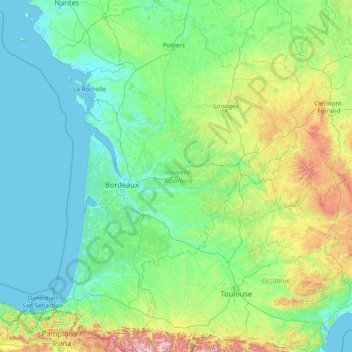
Name: Nouvelle-Aquitaine topographic map, elevation, terrain.
Location: Nouvelle-Aquitaine, Metropolitan France, France (42.77754 -1.79102 47.17592 2.61150)
Average elevation: 258 m
Minimum elevation: -2 m
Maximum elevation: 3,093 m
The climate in Angoumois and Limousin is wetter and cooler, remains temperate with warm spring and has relatively warm summers, with variations due to altitude. The annual sunshine averages at 1850 hours. The climate of the Basque country and southern Landes is marked by its warm summers, mild winters but especially by its high rainfall, with Atlantic depressions that hit the Pyrenean foothills. This Microclimate explains the presence of lush vegetation and the green aspect of the region. Fogs are not rare, but usually dissipate very quickly.
Other topographic maps
Click on a map to view its topography, its elevation and its terrain.
Marseille
France > Provence-Alpes-Côte d'Azur > Bouches-du-Rhône
Marseille, Bouches-du-Rhône, Provence-Alpes-Côte d'Azur, Metropolitan France, France
Average elevation: 94 m
Gibourne
France > Nouvelle-Aquitaine > Charente-Maritime
Gibourne, Saint-Jean-d'Angély, Charente-Maritime, Nouvelle-Aquitaine, Metropolitan France, 17160, France
Average elevation: 75 m
Mars
France > Auvergne-Rhône-Alpes > Ardèche
Mars, Tournon-sur-Rhône, Ardèche, Auvergne-Rhône-Alpes, Metropolitan France, 07320, France
Average elevation: 1,029 m
Plonéour-Lanvern
Plonéour-Lanvern, Quimper, Finistère, Brittany, Metropolitan France, 29720, France
Average elevation: 38 m
Aiguillon
France > Nouvelle-Aquitaine > Lot-et-Garonne
Aiguillon, Agen, Lot-et-Garonne, Nouvelle-Aquitaine, Metropolitan France, 47190, France
Average elevation: 54 m
Pornic
France > Pays de la Loire > Loire-Atlantique
Pornic, Saint-Nazaire, Loire-Atlantique, Pays de la Loire, Metropolitan France, 44210, France
Average elevation: 15 m
Nantes
France > Pays de la Loire > Loire-Atlantique
Nantes, Loire-Atlantique, Pays de la Loire, Metropolitan France, France
Average elevation: 26 m
Barricata
France > Nouvelle-Aquitaine > Pyrénées-Atlantiques > Aussurucq > Etxakokua
Barricata, Zuberoa, Etxakokua, Aussurucq, Oloron-Sainte-Marie, Pyrénées-Atlantiques, Nouvelle-Aquitaine, Metropolitan France, 64130, France
Average elevation: 260 m
Amboise
France > Centre-Val de Loire > Indre-et-Loire
Amboise, Loches, Indre-et-Loire, Centre-Val de Loire, Metropolitan France, 37400, France
Average elevation: 91 m
Mhère
France > Bourgogne – Franche-Comté > Nièvre
Mhère, Clamecy, Nièvre, Bourgogne – Franche-Comté, Metropolitan France, 58140, France
Average elevation: 364 m
Saint-Léger
France > Hauts-de-France > Pas-de-Calais
Saint-Léger, Arras, Pas-de-Calais, Hauts-de-France, Metropolitan France, 62128, France
Average elevation: 99 m
Aisne
Aisne, Hauts-de-France, Metropolitan France, France
Average elevation: 133 m
Berg-sur-Moselle
Berg-sur-Moselle, Thionville, Moselle, Grand Est, Metropolitan France, 57570, France
Average elevation: 168 m
Martigues
France > Provence-Alpes-Côte d'Azur > Bouches-du-Rhône
Martigues, Istres, Bouches-du-Rhône, Provence-Alpes-Côte d'Azur, Metropolitan France, France
Average elevation: 35 m
1st Arrondissement
France > Auvergne-Rhône-Alpes > Métropole de Lyon > Lyon
1st Arrondissement, Lyon, Métropole de Lyon, Rhône, Auvergne-Rhône-Alpes, Metropolitan France, 69001, France
Average elevation: 210 m
9th Arrondissement
France > Ile-de-France > Paris
9th Arrondissement, Paris, Ile-de-France, Metropolitan France, 75009, France
Average elevation: 60 m
4th Arrondissement
France > Ile-de-France > Paris
4th Arrondissement, Paris, Ile-de-France, Metropolitan France, 75004, France
Average elevation: 47 m
10th Arrondissement
France > Ile-de-France > Paris
10th Arrondissement, Paris, Ile-de-France, Metropolitan France, 75010, France
Average elevation: 59 m
1st Arrondissement
France > Ile-de-France > Paris
1st Arrondissement, Paris, Ile-de-France, Metropolitan France, 75001, France
Average elevation: 46 m
3rd Arrondissement
France > Ile-de-France > Paris
3rd Arrondissement, Paris, Ile-de-France, Metropolitan France, 75003, France
Average elevation: 49 m
2nd Arrondissement
France > Ile-de-France > Paris
2nd Arrondissement, Paris, Ile-de-France, Metropolitan France, 75002, France
Average elevation: 49 m
Surgères
France > Nouvelle-Aquitaine > Charente-Maritime
Surgères, Rochefort, Charente-Maritime, Nouvelle-Aquitaine, Metropolitan France, 17700, France
Average elevation: 35 m
Serrières-en-Chautagne
France > Auvergne-Rhône-Alpes > Savoy
Serrières-en-Chautagne, Chambéry, Savoy, Auvergne-Rhône-Alpes, Metropolitan France, 73310, France
Average elevation: 469 m
18th Arrondissement
France > Ile-de-France > Paris
18th Arrondissement, Paris, Ile-de-France, Metropolitan France, 75018, France
Average elevation: 59 m
Noumea
Noumea, South Province, New Caledonia, 98800, France
Average elevation: 8 m
Aubagne
France > Provence-Alpes-Côte d'Azur > Bouches-du-Rhône
Aubagne, Marseille, Bouches-du-Rhône, Provence-Alpes-Côte d'Azur, Metropolitan France, 13400, France
Average elevation: 219 m
Lifou
France > Loyalty Islands Province
Lifou, Loyalty Islands Province, New Caledonia, 98820, France
Average elevation: 16 m
Bazoches-sur-Guyonne
France > Ile-de-France > Yvelines
Bazoches-sur-Guyonne, Rambouillet, Yvelines, Ile-de-France, Metropolitan France, 78490, France
Average elevation: 104 m
Hagenthal-le-Bas
France > Grand Est > Haut-Rhin
Hagenthal-le-Bas, Mulhouse, Haut-Rhin, Grand Est, Metropolitan France, 68220, France
Average elevation: 395 m
Paillet
France > Nouvelle-Aquitaine > Gironde
Paillet, Langon, Gironde, Nouvelle-Aquitaine, Metropolitan France, 33550, France
Average elevation: 34 m
Coust
France > Centre-Val de Loire > Cher
Coust, Saint-Amand-Montrond, Cher, Centre-Val de Loire, Metropolitan France, 18210, France
Average elevation: 201 m
Lisses
France > Ile-de-France > Essonne
Lisses, Évry, Essonne, Ile-de-France, Metropolitan France, 91090, France
Average elevation: 78 m
Kermorheven
France > Brittany > Morbihan > Pluméliau-Bieuzy
Kermorheven, Pluméliau, Pluméliau-Bieuzy, Pontivy, Morbihan, Brittany, Metropolitan France, 56930, France
Average elevation: 85 m
Marcoux
France > Provence-Alpes-Côte d'Azur > Alpes-de-Haute-Provence
Marcoux, Digne-les-Bains, Alpes-de-Haute-Provence, Provence-Alpes-Côte d'Azur, Metropolitan France, 04420, France
Average elevation: 819 m
Clédat
France > Nouvelle-Aquitaine > Corrèze > Grandsaigne
Clédat, Grandsaigne, Tulle, Corrèze, Nouvelle-Aquitaine, Metropolitan France, 19300, France
Average elevation: 761 m
Lestards
France > Nouvelle-Aquitaine > Corrèze
Lestards, Tulle, Corrèze, Nouvelle-Aquitaine, Metropolitan France, 19170, France
Average elevation: 683 m
Lake Geneva
France > Auvergne-Rhône-Alpes > Upper Savoy
Lake Geneva, Upper Savoy, Auvergne-Rhône-Alpes, Metropolitan France, 1898, France
Average elevation: 798 m
Orion
France > Nouvelle-Aquitaine > Pyrénées-Atlantiques
Orion, Oloron-Sainte-Marie, Pyrénées-Atlantiques, Nouvelle-Aquitaine, Metropolitan France, 64390, France
Average elevation: 156 m
Saint-Didier-au-Mont-d'Or
France > Auvergne-Rhône-Alpes > Métropole de Lyon
Saint-Didier-au-Mont-d'Or, Lyon, Métropole de Lyon, Rhône, Auvergne-Rhône-Alpes, Metropolitan France, 69370, France
Average elevation: 322 m