
Make a donation
Royton topographic map
Click on the map to display elevation.
Make a donation
Royton
Described in Samuel Lewis's A Topographical Dictionary of England (1848) as being in "aspect rather wild", Royton lies in a shallow valley amongst undulating land. The sources of the rivers Irk and Beal are to the northeast and east respectively. The Irk meanders southwesterly into Chadderton, and then onwards to Middleton into Manchester before uniting its waters with the River Irwell in Manchester city centre. The general slope of the land decreases in height away from the Pennines, from east to west, but reaches high points of 509 feet (155 m) at Tandle Hill and 825 feet (251 m) at the summit of Oldham Edge, a ridge of elevated land which leads to Oldham. The soils of the town are broadly sand with subsoils of clay.
Make a donation
About this map
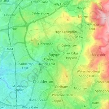
Name: Royton topographic map, elevation, terrain.
Average elevation: 181 m
Minimum elevation: 86 m
Maximum elevation: 393 m
Make a donation
Other topographic maps
Click on a map to view its topography, its elevation and its terrain.
Lincoln
United Kingdom > England > Lincolnshire
Lincoln lies at an altitude of 67 ft (20.4 m) by the River Witham up to 246 ft (75.0 m) on Castle Hill. It fills a gap in the Lincoln Cliff escarpment, which runs north and south through Central Lincolnshire, with altitudes up to 200 feet (61 metres). The city lies on the River Witham, which flows through this…
Average elevation: 29 m
Lickey Hills Country Park
United Kingdom > England > Worcestershire > Bromsgrove > Cofton Hackett CP
The visitor centre, which first opened in April 1990, contains an exhibition, leaflets and information on nature trails, guided walks and other activities organised by the Ranger Service. It also has a small café and gift shop. There are three car parks, one for the visitor centre, one by the golf club house…
Average elevation: 208 m
Make a donation
Leicestershire
A large part of the north-west of the county, around Coalville, forms part of the new National Forest area extending into Derbyshire and Staffordshire. The highest point of the county is Bardon Hill at 278 m (912 ft), which is also a Marilyn; with other hilly/upland areas of c. 150–200 metres (490–660 ft)…
Average elevation: 97 m
Make a donation
Make a donation
Make a donation
Derbyshire
Because of its central location in England and altitude range from 27 metres in the south to 636 metres in the north, Derbyshire contains many species at the edge of their UK distribution ranges. Some species with a predominantly northern British distribution are at the southern limit of their range, whilst…
Average elevation: 144 m
Ludlow
United Kingdom > England > Shropshire
During the 12th century, the planned town of Ludlow was formed, in stages, the town providing a useful source of income for successive Marcher Lords, based on rents, fines, and tolls. They developed the town on a regular grid pattern, although this was adapted somewhat to match the local topography, from the…
Average elevation: 108 m
Make a donation
Make a donation
Shrewsbury
United Kingdom > England > Shropshire
The town centre is partially built on a hill whose elevation is, at its highest, 246 feet (75 m) above sea level. The longest river in the United Kingdom, the River Severn, flows through the town, forming a meander around its centre. The Rea Brook is a small river that has its confluence with the Severn at…
Average elevation: 69 m
Make a donation
Make a donation
Make a donation
Make a donation
Make a donation
Make a donation
Make a donation
Make a donation
Make a donation
Make a donation
Make a donation
Make a donation
Suffolk
The west of the county lies on more resistant Cretaceous chalk. This chalk is responsible for a sweeping tract of largely downland landscapes that stretches from Dorset in the south west to Dover in the south east and north through East Anglia to the Yorkshire Wolds. The chalk is less easily eroded so forms…
Average elevation: 35 m
Make a donation
Downham Market
United Kingdom > England > Norfolk > King's Lynn and West Norfolk
Average elevation: 20 m
Make a donation
Make a donation
Tickhill
United Kingdom > England > Doncaster
It lies eight miles south of Doncaster, between Maltby and Harworth, on the busy conjunction of the A631 and A60 roads, and adjacent to the A1(M) motorway. It is located at 53° 26' North, 1° 6' 40" West, at an elevation of around 20 metres above sea level. The River Torne passes close to the south-east of…
Average elevation: 28 m
Bishop's Stortford
United Kingdom > England > Hertfordshire > East Hertfordshire
Stortford, along with the rest of Britain, has a temperate maritime climate, with cool summers and mild winters. The nearest weather station for which averages and extremes are available is Stansted Airport, about 2+1⁄2 miles (4 kilometres) due east of Stortford's town centre. Located at an elevation of over…
Average elevation: 83 m
Make a donation
Make a donation
Cobham
United Kingdom > England > Surrey > Elmbridge
The River Mole runs through Cobham, with a visitor area and well-surfaced path by the mill in the High Street, dividing the remaining agricultural parts of Cobham in the west and south. Elevation reaches a minimum here of 20 metres (66 ft) above sea level.
Average elevation: 28 m
Make a donation
Make a donation