
Phuket Province topographic map
Interactive map
Click on the map to display elevation.
About this map
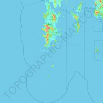
Name: Phuket Province topographic map, elevation, terrain.
Location: Phuket Province, Thailand (7.26118 98.06489 8.20219 98.49250)
Average elevation: 5 m
Minimum elevation: -1 m
Maximum elevation: 493 m
Other topographic maps
Click on a map to view its topography, its elevation and its terrain.
Ban Huai Pod
Ban Huai Pod, That, Loei Province, Thailand
Average elevation: 246 m
Khao Hua Chang
Thailand > Phatthalung Province
Khao Hua Chang, Phatthalung Province, Thailand
Average elevation: 206 m
Pattani
Pattani, Ru Samilae, Pattani Province, 94000, Thailand
Average elevation: 3 m
Patong
Thailand > Phuket Province > Kathu
Patong, Kathu, Phuket Province, 83159, Thailand
Average elevation: 123 m
Ban Nong Yai
Ban Nong Yai, Sa Kamphaeng Yai, Si Sa Ket Province, Thailand
Average elevation: 145 m
Damnoen Saduak
Thailand > Ratchaburi Province
Damnoen Saduak, Si Don Phai, Ratchaburi Province, 70130, Thailand
Average elevation: 5 m
homo erectus and mammoth park
homo erectus and mammoth park, Thung Phaya Thai Subdistrict, Ratchathewi District, Bangkok, 10400, Thailand
Average elevation: 7 m
Mekong River
Thailand > Nong Khai Province > Si Chiang Mai
Mekong River, Si Chiang Mai, Kong Nang, Nong Khai Province, Thailand
Average elevation: 170 m
Ban Pa Daet North
Thailand > Chiang Mai Province
Ban Pa Daet North, Pa Daet, Saraphi District, Chiang Mai Province, 50100, Thailand
Average elevation: 304 m
Ban Nong Kha Tae
Thailand > Chiang Mai Province
Ban Nong Kha Tae, Mueang Ngai, Chiang Mai Province, Thailand
Average elevation: 1,250 m
Maha Phram Subdistrict Municipality
Thailand > Phra Nakhon Si Ayutthaya Province > Bang Ban District
Maha Phram Subdistrict Municipality, Bang Ban District, Phra Nakhon Si Ayutthaya Province, 13250, Thailand
Average elevation: 5 m
Phetchabun
Thailand > Phetchabun Province
Phetchabun, Phetchabun Province, 67000, Thailand
Average elevation: 120 m
Phuket
Thailand > Phuket Province > Phuket
Phuket, Phuket Province, 83000, Thailand
Average elevation: 22 m
Haad Chaloklum
Thailand > Surat Thani Province > Moo 7
Haad Chaloklum, Baan Chaloklum, Moo 7, Surat Thani Province, Thailand
Average elevation: 82 m
Ko Samui
Thailand > Surat Thani Province
Ko Samui, Surat Thani Province, Thailand
Average elevation: 75 m
Phetchaburi Province
Thailand > Phetchaburi Province
Phetchaburi Province, Thailand
Average elevation: 105 m
Ban Nong Na Dam
Thailand > Phichit Province > Ban Nong Na Dam
Ban Nong Na Dam, Phichit Province, Thailand
Average elevation: 37 m
Ban Chang
Thailand > Rayong Province > Ban Chang
Ban Chang, Rayong Province, TUNG PONG, Thailand
Average elevation: 58 m
Ban Khun Khlang
Thailand > Chiang Mai Province > Ban Khun Khlang
Ban Khun Khlang, Chiang Mai Province, Thailand
Average elevation: 1,392 m
Ban Mai Subdistrict
Thailand > Nonthaburi Province > Ban Mai Subdistrict
Ban Mai Subdistrict, Pak Kret District, Nonthaburi Province, 11120, Thailand
Average elevation: 4 m
Doi Pha Hom Pok National Park
Thailand > Chiang Mai Province > Ban Huey Mak Liam
Doi Pha Hom Pok National Park, ชม.3015, Ban Huey Mak Liam, Chiang Mai Province, Thailand
Average elevation: 847 m
Ban Khok
Thailand > Si Sa Ket Province > Ban Khok
Ban Khok, Si Sa Ket Province, Thailand
Average elevation: 147 m
Pak Nam
Thailand > Suphan Buri Province > Pak Nam
Pak Nam, Suphan Buri Province, Thailand
Average elevation: 14 m
Khao luang
Thailand > Nakhon Si Thammarat Province > Nakhon Si Thammarat
Khao luang, Nakhon Si Thammarat, Nakhon Si Thammarat Province, Thailand
Average elevation: 1,286 m
Ban Luang
Thailand > Lampang Province > Ban Luang
Ban Luang, Lampang Province, Thailand
Average elevation: 383 m
Laem Pho
Thailand > Krabi Province > Haad Yao
Laem Pho, Haad Yao, Krabi Province, Thailand
Average elevation: 8 m