
Make a donation
Vincent Community topographic map
Click on the map to display elevation.
Make a donation
About this map
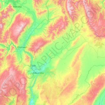
Name: Vincent Community topographic map, elevation, terrain.
Average elevation: 776 m
Minimum elevation: 89 m
Maximum elevation: 2,083 m
Central Otago District trails, hiking, mountain biking, running and outdoor activities
Make a donation
Other topographic maps
Click on a map to view its topography, its elevation and its terrain.
Ida Valley
New Zealand > Otago > Central Otago District > Maniototo Community
Average elevation: 472 m
Cromwell
New Zealand > Otago > Central Otago District > Cromwell Community > Cromwell
Average elevation: 330 m
Roxburgh
New Zealand > Otago > Central Otago District > Teviot Valley Community
Average elevation: 223 m
Make a donation
Muttontown
New Zealand > Otago > Central Otago District > Vincent Community > Clyde
Average elevation: 207 m
Blackstone Hill
New Zealand > Otago > Central Otago District > Vincent Community
Average elevation: 789 m
Make a donation
Blue Lake
New Zealand > Otago > Central Otago District > Vincent Community > Saint Bathans
Average elevation: 605 m
Ettrick
New Zealand > Otago > Central Otago District > Teviot Valley Community
Average elevation: 105 m