
Kakanui Peak topographic map
Interactive map
Click on the map to display elevation.
About this map
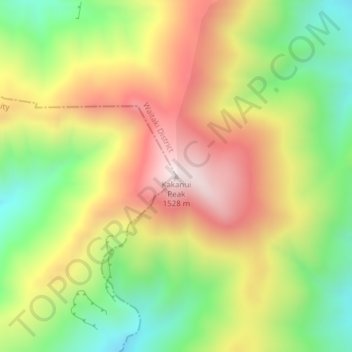
Name: Kakanui Peak topographic map, elevation, terrain.
Location: Kakanui Peak, Central Otago District, Otago, New Zealand (-45.13369 170.43930 -45.13359 170.43940)
Average elevation: 1,169 m
Minimum elevation: 845 m
Maximum elevation: 1,519 m
Routes: Central Otago District GPS tracks, routes, trails, hikes
Other topographic maps
Click on a map to view its topography, its elevation and its terrain.
Cromwell
New Zealand > Otago > Central Otago District > Cromwell Community > Cromwell
Average elevation: 330 m
Clyde Dam
New Zealand > Otago > Central Otago District > Vincent Community > Clyde
Average elevation: 318 m
Blue Lake
New Zealand > Otago > Central Otago District > Vincent Community > Saint Bathans
Average elevation: 605 m
Ranfurly
New Zealand > Otago > Central Otago District
Ranfurly is a town in the Central Otago District of Otago, New Zealand. Located 110 kilometres (68 miles) north of Dunedin, it lies in the dry rough plain of Maniototo at a moderately high altitude (around 430 metres or 1,410 feet above sea level) close to a small tributary of the Taieri River. It operates as…
Average elevation: 429 m
Central Otago
New Zealand > Otago > Central Otago District > Vincent Community
Average elevation: 935 m
Shingle Creek
New Zealand > Otago > Central Otago District > Teviot Valley Community
Average elevation: 307 m
Roxburgh
New Zealand > Otago > Central Otago District > Teviot Valley Community
Average elevation: 223 m
Blackstone Hill
New Zealand > Otago > Central Otago District > Vincent Community
Average elevation: 789 m
Ida Valley
New Zealand > Otago > Central Otago District > Maniototo Community
Average elevation: 472 m
Muttontown
New Zealand > Otago > Central Otago District > Vincent Community > Clyde
Average elevation: 207 m
Millers Flat
New Zealand > Otago > Central Otago District > Teviot Valley Community
Average elevation: 161 m
Naseby
New Zealand > Otago > Central Otago District
Naseby is a small town, formerly a borough, in the Maniototo area of Central Otago, New Zealand. It is named after a village in Northamptonshire, England. Previous names of the township were Parker's, Hogburn and Mt Ida. The town catch phrase is "2000 feet above worry level" indicating its altitude. Naseby is…
Average elevation: 617 m