
Chiang Mai Province topographic map
Interactive map
Click on the map to display elevation.
Chiang Mai Province
Chiang Mai province is about 685 km (426 mi) from Bangkok in the Mae Ping River basin and is on average at 300 m (1,000 ft) elevation. Surrounded by the mountain ranges of the Thai highlands, it covers an area of approximately 22,135 km2 (9,000 sq mi). The mountains of the Daen Lao Range (ทิวเขาแดนลาว) at the north end of the province, the Thanon Thong Chai Range (เทือกเขาถนนธงชัย) with the highest mountain in Thailand, Doi Inthanon at 2,565 metres (8,415 ft), stretching in a north–south direction, and the Khun Tan Range in the east of the province are covered by rain forest. The Mae Ping, one of the major tributaries of the Chao Phraya River, originates in the Daen Lao mountains. Several national parks are in the province: Doi Inthanon, Doi Suthep-Pui, Ob Luang, Sri Lanna, Huai Nam Dang, Mae Wang, and Pha Daeng. The total forest area is 15,404 km2 (5,948 sq mi) or 69.6 percent of provincial area.
About this map
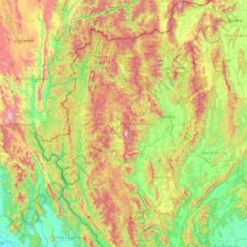
Name: Chiang Mai Province topographic map, elevation, terrain.
Location: Chiang Mai Province, Thailand (17.24833 98.08083 20.14758 99.57585)
Average elevation: 649 m
Minimum elevation: -1 m
Maximum elevation: 2,541 m
Other topographic maps
Click on a map to view its topography, its elevation and its terrain.
Chiang Mai
The city is situated in a valley on a river basin in the Thai highlands and is on average at 300 m (1,000 ft) elevation. Chiang Mai's city centre sits west of the Ping River, a tributary to the Chao Phraya River, while the city's sprawl extends north-west, south-west, north-east and east of the river. To the…
Average elevation: 424 m
Tham Luang-Khun Nam Nang Non Forest Park
Thailand > Mae Sai district > Ban Pha Hi
Average elevation: 661 m
Bangkok
Bangkok is situated in the Chao Phraya River delta in Thailand's central plain. The river meanders through the city in a southerly direction, emptying into the Gulf of Thailand approximately 25 kilometres (16 mi) south of city centre. The area is flat and low-lying, with an average elevation of 1.5 metres (4…
Average elevation: 4 m
Phuket Province
Although some recent geographical works refer to the sections of the Tenasserim Hills in the isthmus as the "Phuket Range", these names are not found in classical geographic sources. Besides, the name Phuket is relatively recent having previously been named Jung Ceylon and Thalang. The highest elevation of the…
Average elevation: 24 m