
Thank you for supporting this site ❤️
Make a donation
Make a donation
Cardona topographic map
Click on the map to display elevation.
Thank you for supporting this site ❤️
Make a donation
Make a donation
About this map
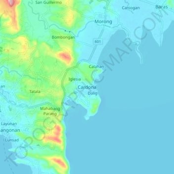
Name: Cardona topographic map, elevation, terrain.
Location: Cardona, Rizal, Calabarzon, 1950, Philippines (14.44491 121.19034 14.52491 121.27034)
Average elevation: 28 m
Minimum elevation: -5 m
Maximum elevation: 223 m
Thank you for supporting this site ❤️
Make a donation
Make a donation
Other topographic maps
Click on a map to view its topography, its elevation and its terrain.
Thank you for supporting this site ❤️
Make a donation
Make a donation
Thank you for supporting this site ❤️
Make a donation
Make a donation
Thank you for supporting this site ❤️
Make a donation
Make a donation