
Thank you for supporting this site ❤️
Make a donation
Make a donation
San Roque topographic map
Click on the map to display elevation.
Thank you for supporting this site ❤️
Make a donation
Make a donation
About this map
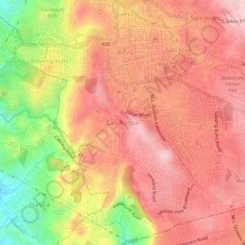
Name: San Roque topographic map, elevation, terrain.
Location: San Roque, Rizal, Calabarzon, 1910, Philippines (14.55401 121.15115 14.59401 121.19115)
Average elevation: 174 m
Minimum elevation: 34 m
Maximum elevation: 249 m
Thank you for supporting this site ❤️
Make a donation
Make a donation
Other topographic maps
Click on a map to view its topography, its elevation and its terrain.
Thank you for supporting this site ❤️
Make a donation
Make a donation
Thank you for supporting this site ❤️
Make a donation
Make a donation
Thank you for supporting this site ❤️
Make a donation
Make a donation