Geolocate

Tuamarina River topographic map

Interactive map

Click on the map to display elevation.

About this map

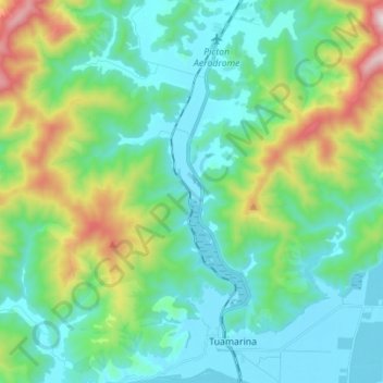
Name: Tuamarina River topographic map, elevation, terrain.

Location: Tuamarina River, Marlborough, 7246, New Zealand (-41.43949 173.94509 -41.33526 173.96624)

Average elevation: 223 m

Minimum elevation: 0 m

Maximum elevation: 956 m

Marlborough trails, hiking, mountain biking, running and outdoor activities

Other topographic maps

Click on a map to view its topography, its elevation and its terrain.

Manakau Hill

New Zealand > Marlborough

Average elevation: 49 m

Canvastown

New Zealand > Marlborough

Average elevation: 133 m

Waikawa

New Zealand > Marlborough

Average elevation: 49 m

Elevation

New Zealand > Marlborough > Picton

Average elevation: 172 m

Devils Staircase

New Zealand > Marlborough

Average elevation: 372 m

d'Urville Island

New Zealand > Marlborough

Average elevation: 48 m

Hossack Saddle

New Zealand > Marlborough

Average elevation: 875 m

Renwick

New Zealand > Marlborough

Average elevation: 52 m

Rapaura

New Zealand > Marlborough

Average elevation: 19 m

Waitaria Bay

New Zealand > Marlborough

Average elevation: 108 m

Nydia Bay

New Zealand > Marlborough

Average elevation: 91 m

Ward

New Zealand > Marlborough > Ward

Average elevation: 61 m