Geolocate

Renwick topographic map

Interactive map

Click on the map to display elevation.

About this map

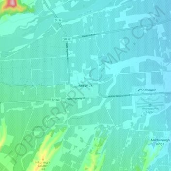
Name: Renwick topographic map, elevation, terrain.

Location: Renwick, Marlborough, 7204, New Zealand (-41.54831 173.78901 -41.46831 173.86901)

Average elevation: 52 m

Minimum elevation: 21 m

Maximum elevation: 281 m

Marlborough trails, hiking, mountain biking, running and outdoor activities

Other topographic maps

Click on a map to view its topography, its elevation and its terrain.

Leatham River

New Zealand > Marlborough

Average elevation: 1,234 m

d'Urville Island

New Zealand > Marlborough

Average elevation: 48 m

Kaituna River

New Zealand > Marlborough > Havelock

Average elevation: 268 m

White Bluffs

New Zealand > Marlborough

Average elevation: 61 m

Tuamarina River

New Zealand > Marlborough

Average elevation: 223 m

Waikawa Stream

New Zealand > Marlborough > Waikawa

Average elevation: 71 m

Totaranui Stream

New Zealand > Marlborough

Average elevation: 177 m

Waima River

New Zealand > Marlborough

Average elevation: 306 m