
Saint Louis County topographic map
Interactive map
Click on the map to display elevation.
About this map
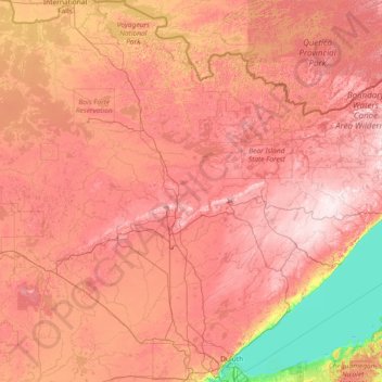
Name: Saint Louis County topographic map, elevation, terrain.
Location: Saint Louis County, Minnesota, United States (46.64916 -93.09664 48.63156 -91.78932)
Average elevation: 398 m
Minimum elevation: 176 m
Maximum elevation: 624 m
Other topographic maps
Click on a map to view its topography, its elevation and its terrain.
Minnehaha Regional Park
United States > Minnesota > Hennepin County > Minneapolis
Fortunately for the generations to come, in 1883 the state legislature created the Minneapolis Board of Park Commissioners. The board began by acquiring park land near today's downtown Minneapolis. Their choice to hire noted landscape architect Horace Cleveland was fortunate. Cleveland was hired by the Board…
Average elevation: 249 m