
Horseshoe Island topographic map
Interactive map
Click on the map to display elevation.
About this map
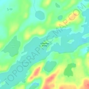
Name: Horseshoe Island topographic map, elevation, terrain.
Location: Horseshoe Island, Lake County, Minnesota, United States (48.02768 -91.45196 48.03251 -91.44240)
Average elevation: 419 m
Minimum elevation: 400 m
Maximum elevation: 455 m
Other topographic maps
Click on a map to view its topography, its elevation and its terrain.
Fillmore County
The county is part of the Driftless Area or Paleozoic plateau. This part of Minnesota was ice-free during the last ice age. Fillmore County also displays a karst topography.
Average elevation: 363 m
Minneapolis
United States > Minnesota > Hennepin County
A 1959 report by the US Soil Conservation Service listed Minneapolis's elevation above mean sea level as 830 feet (250 meters). The city's lowest elevation of 687 feet (209 m) above sea level is near the confluence of Minnehaha Creek with the Mississippi River. Sources disagree on the exact location and…
Average elevation: 270 m
Remer
United States > Minnesota > Cass County
According to the United States Census Bureau, the city has an area of 1.38 square miles (3.57 km2), all land. The elevation is 1,342 ft (409 m) above sea level.
Average elevation: 408 m
Rochester
United States > Minnesota > Olmsted County
With a slightly higher altitude and without the UHI as the Twin Cities, the climate is warm-summer humid continental climate (Köppen: Dfb) even being further south, with warm summers and cold winters. The city features four distinct seasons. Rochester sees on average 33.02 inches (839 mm) of rainfall and 51.9…
Average elevation: 354 m
Duluth
United States > Minnesota > Saint Louis County
Duluth's topography is dominated by a steep hillside that climbs from Lake Superior to high inland elevations. Duluth has been called "the San Francisco of the Midwest," alluding to San Francisco's similar water-to-hilltop topography. This similarity was most evident before World War II, when Duluth had a…
Average elevation: 286 m
Crow Wing County
Crow Wing County has two state forests, the Crow Wing State Forest and the Emily State Forest. The Cuyuna Lakes State Trail lies in the Upper Mississippi River Basin. The topography is gently rolling to flat, mostly wooded and heavily dotted with waters and wetlands. It is home to an abundance of wildlife,…
Average elevation: 386 m
Champlin
United States > Minnesota > Champlin
The average elevation is 875 feet (267 m) above sea level, and the Mississippi River is approximately one-eighth of a mile wide throughout Champlin.
Average elevation: 265 m
Becker County
Becker County has diverse topography. It is home to several hundred lakes, many acres of fertile farm land, and forested areas. Much of the land consists of hills and deciduous trees.
Average elevation: 439 m