
Ranfurly topographic map
Interactive map
Click on the map to display elevation.
About this map
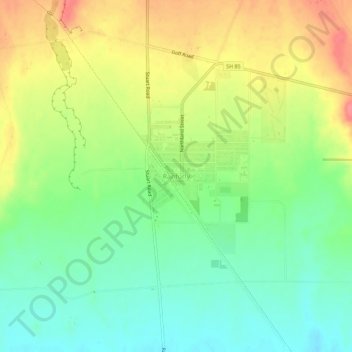
Name: Ranfurly topographic map, elevation, terrain.
Location: Ranfurly, Central Otago District, Otago, 9332, New Zealand (-45.14953 170.07978 -45.10953 170.11978)
Average elevation: 429 m
Minimum elevation: 397 m
Maximum elevation: 472 m
Ranfurly is a town in the Central Otago District of Otago, New Zealand. Located 110 kilometres (68 miles) north of Dunedin, it lies in the dry rough plain of Maniototo at a moderately high altitude (around 430 metres or 1,410 feet above sea level) close to a small tributary of the Taieri River. It operates as a service town for the local farming community. The town was formerly known as Eweburn, one of the "farmyard" names bestowed by former Otago Chief Surveyor John Turnbull Thomson on many small streams and locations in the district. The modern name honours the Fifth Earl of Ranfurly, who served as Governor of New Zealand (1897–1904) at the time of the extension of the Otago Central Railway to the area. Ranfurly is well known for its Art Deco buildings, such as its hotel and the milk bar.
Other topographic maps
Click on a map to view its topography, its elevation and its terrain.
Becks
New Zealand > Otago > Central Otago District > Vincent Community
Becks, Vincent Community, Central Otago District, Otago, 9377, New Zealand
Average elevation: 393 m
Cromwell
New Zealand > Otago > Central Otago District > Cromwell Community > Cromwell
Cromwell, Cromwell Community, Central Otago District, Otago, 9310, New Zealand
Average elevation: 330 m
Blue Lake
New Zealand > Otago > Central Otago District > Vincent Community > Saint Bathans
Blue Lake, Saint Bathans, Vincent Community, Central Otago District, Otago, New Zealand
Average elevation: 605 m
Kakanui Peak
New Zealand > Otago > Central Otago District
Kakanui Peak, Central Otago District, Otago, New Zealand
Average elevation: 1,169 m
Central Otago
New Zealand > Otago > Central Otago District > Vincent Community
Central Otago, Vincent Community, Central Otago District, Otago, 9035, New Zealand
Average elevation: 935 m
Shingle Creek
New Zealand > Otago > Central Otago District > Teviot Valley Community
Shingle Creek, Teviot Valley Community, Central Otago District, Otago, New Zealand
Average elevation: 307 m
Blackstone Hill
New Zealand > Otago > Central Otago District > Vincent Community
Blackstone Hill, Vincent Community, Central Otago District, Otago, 9377, New Zealand
Average elevation: 789 m
Alexandra
New Zealand > Otago > Central Otago District > Vincent Community
Alexandra, Vincent Community, Central Otago District, Otago, 9320, New Zealand
Average elevation: 241 m
Ophir
New Zealand > Otago > Central Otago District > Vincent Community
Ophir, Vincent Community, Central Otago District, Otago, 9376, New Zealand
Average elevation: 338 m
Roxburgh
New Zealand > Otago > Central Otago District > Teviot Valley Community
Roxburgh, Teviot Valley Community, Central Otago District, Otago, 9500, New Zealand
Average elevation: 223 m
Clyde
New Zealand > Otago > Central Otago District > Vincent Community
Clyde, Vincent Community, Central Otago District, Otago, 9330, New Zealand
Average elevation: 316 m
Cromwell Community
New Zealand > Otago > Central Otago District
Cromwell Community, Central Otago District, Otago, New Zealand
Average elevation: 876 m
Ida Valley
New Zealand > Otago > Central Otago District > Maniototo Community
Ida Valley, Maniototo Community, Central Otago District, Otago, New Zealand
Average elevation: 472 m
Muttontown
New Zealand > Otago > Central Otago District > Vincent Community > Clyde
Muttontown, Clyde, Vincent Community, Central Otago District, Otago, 9391, New Zealand
Average elevation: 207 m
Millers Flat
New Zealand > Otago > Central Otago District > Teviot Valley Community
Millers Flat, Teviot Valley Community, Central Otago District, Otago, 9572, New Zealand
Average elevation: 161 m
Naseby
New Zealand > Otago > Central Otago District
Naseby, Central Otago District, Otago, 9396, New Zealand
Average elevation: 617 m
Wedderburn
New Zealand > Otago > Central Otago District
Wedderburn, Central Otago District, Otago, 9395, New Zealand
Average elevation: 565 m