
Shetland topographic map
Interactive map
Click on the map to display elevation.
About this map
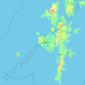
Name: Shetland topographic map, elevation, terrain.
Location: Shetland, Shetland Islands, Scotland, United Kingdom (59.85227 -1.70414 60.63958 -1.04900)
Average elevation: 11 m
Minimum elevation: -3 m
Maximum elevation: 441 m
Other topographic maps
Click on a map to view its topography, its elevation and its terrain.
Bathgate
United Kingdom > Scotland > West Lothian
In the 1846 book A Topographical Dictionary of Scotland, Samuel Lewis writes.
Average elevation: 167 m
Kilsyth
United Kingdom > Scotland > North Lanarkshire
Historically part of Stirlingshire, Kilsyth is at an elevation of 200 feet (60 metres) above sea level and occupies a narrow strip of land between the Kilsyth Hills to the north and the River Kelvin to the south. To the east and west it is bordered by marshland and bogs. The centre of the town is close to the…
Average elevation: 161 m
Strathpeffer
United Kingdom > Scotland > Highland
It lies in a strath 5 miles (8 km) west of Dingwall, with the elevation ranging from 60 to 120 m (200 to 400 ft) above sea level. Sheltered on the west and north, it has a comparatively dry and warm climate.
Average elevation: 127 m
Scottish Highlands
United Kingdom > Scotland > Highland
The entire region was covered by ice sheets during the Pleistocene ice ages, save perhaps for a few nunataks. The complex geomorphology includes incised valleys and lochs carved by the action of mountain streams and ice, and a topography of irregularly distributed mountains whose summits have similar heights…
Average elevation: 907 m
Ormiston
United Kingdom > Scotland > East Lothian > Ormiston
Ormiston is a village in East Lothian, Scotland, near Tranent, Humbie, Pencaitland and Cranston, located on the north bank of the River Tyne at an elevation of about 276 feet (84 m).
Average elevation: 102 m