
Make a donation
Padre Burgos topographic map
Click on the map to display elevation.
Make a donation
Padre Burgos
On January 1, 1917, the village of Laguimanoc, which was formerly a barrio of Atimonan, became a municipality. On December 3, 1927, the town's name was changed to Padre Burgos by virtue of Act No. 3389, in honor of one of the country's martyrs, Fr. Jose Burgos. The streets were named after local leaders who rendered valuable services to the community. Because of the physical and topographic conditions of the town, four sitios where clusters of houses were became the main district of the town, namely: Campo, Burgos, Basiao and Bundok-Punta. The community converged to be in this particular spot because of its sea which made this town as port of Laguimanoc. In the early days this port offered a good wharf for vessels plying between Manila and southern Luzon. This was also a port of call for ships exporting lumber to Europe during the Spanish regime. In this town was the residence of the “Alcalde Mar” or Port Officer.
Make a donation
About this map
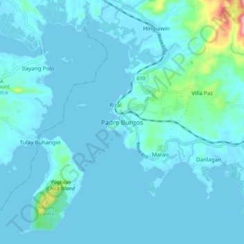
Name: Padre Burgos topographic map, elevation, terrain.
Location: Padre Burgos, Calabarzon, 4303, Philippines (13.87594 121.77495 13.95594 121.85495)
Average elevation: 19 m
Minimum elevation: -1 m
Maximum elevation: 236 m
Make a donation
Other topographic maps
Click on a map to view its topography, its elevation and its terrain.
Make a donation
Mount Banahaw and San Cristobal Protected Landscape
Philippines > Laguna > Liliw
Average elevation: 592 m
Panay
Panay island is the sixth largest island in the Philippines by area, with a total land area of 12,011 km2 (4,637 sq mi). Mount Madja-as is the highest point in Panay with an elevation of 2,117 metres (6,946 ft) above sea level, located in town of Culasi in the northern province of Antique. Central Panay…
Average elevation: 117 m
Make a donation
Negros Island Region
Siquijor is an island located southeast of Negros Oriental. Area-wise, it is the third smallest in the country, with an area of 343.5 square kilometers (132.6 sq mi). Mount Malabahoc, also known as Mount Bandila‑an, is the highest point of the island, with its elevation reaching 628 meters (2,060 ft) above…
Average elevation: 98 m
Make a donation
Make a donation
Impasugong
Impasugong is cool and moist throughout the year due to its high elevation ranging from 500 metres (1,600 ft) to more than 1,000 metres (3,300 ft) above sea level. It is a typhoon-free area ideal for the production of high-value crops. Average temperature ranges from 16 to 31 °C (61 to 88 °F) throughout the…
Average elevation: 903 m
Make a donation
Make a donation
Make a donation
Make a donation
Make a donation
Corregidor Island
Philippines > Cavite > Cavite City
The tadpole-shaped island, with its tail running eastward, is about 6.5 km (4.0 mi) long, about 2.0 km (1.2 mi) wide at its widest with a total land area of about 900 hectares (2,200 acres). The highest elevation is at 180 m (590 ft) on the Topside. The island is divided into four sections.
Average elevation: 11 m
Make a donation
Make a donation
Camiguin
Camiguin Island is a pearl-shaped island with an area of approximately 238 square kilometers (92 sq mi). The island measures about 23 kilometers (14 mi) at its longest and 14.5 kilometers (9.0 mi) at its widest breadth. The island is mountainous with the highest elevation reaching over 5,000 ft (1,500 m). It…
Average elevation: 207 m
Make a donation
Make a donation
Mount Isarog
Philippines > Camarines Sur > Lugsad
Mount Isarog is an active stratovolcano located in the province of Camarines Sur, Philippines, on the island of Luzon. The mountain has active fumaroles and hot springs. It has an elevation of 2,011.6 m (6,600 ft) above mean sea level.
Average elevation: 671 m
Make a donation
Make a donation
Make a donation
Make a donation
Mindanao
In the eastern portion of the island, from Bilas Point in Surigao del Norte to Cape San Agustin in Davao Oriental, is a range of complex mountains known in their northern portion as the Diwata Mountains. This range is low and rolling in its central portion. A proposed road connecting Bislig on the east coast…
Average elevation: 54 m
Make a donation
Make a donation
Make a donation
Make a donation
Make a donation
Make a donation
Make a donation
Siniloan
Buruwisan falls is located in Siniloan Laguna which is around eighty kilometers east of Manila. To get there we had to cross the long winding roads of Teresa and Bugarin to Mabitac. By public transport Take UV express vans bound to Tanay market in Starmall-Shaw terminal (P70). Then in Tanay market, ride a…
Average elevation: 120 m
Make a donation