
Iruhin East topographic map
Interactive map
Click on the map to display elevation.
About this map
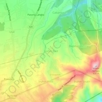
Name: Iruhin East topographic map, elevation, terrain.
Location: Iruhin East, Tagaytay, Cavite, Calabarzon, 4120, Philippines (14.12783 120.98382 14.16783 121.02382)
Average elevation: 496 m
Minimum elevation: 309 m
Maximum elevation: 728 m
Other topographic maps
Click on a map to view its topography, its elevation and its terrain.
Mount Sungay
Philippines > Cavite > Tagaytay > Iruhin South
Mount Sungay is the eastern end of the Tagaytay Range, or more commonly known as the Tagaytay Ridge, a 32-kilometre (20 mi) ridge located at the southern part of the province with elevations averaging about 600 m (2,000 ft) above sea level. The ridge stretches west-southwest from Mount Sungay to Mount Batulao…
Average elevation: 501 m