Geolocate

Sichuan topographic map

Interactive map

Click on the map to display elevation.

Sichuan

Due to great differences in terrain, the climate of the province is highly variable. In general, it has strong monsoonal influences, with rainfall heavily concentrated in the summer. Under the Köppen climate classification, the Sichuan Basin (including Chengdu) in the eastern half of the province experiences a humid subtropical climate (Köppen Cwa or Cfa), with long, hot, wet summers and short, mild to cool, dry, and cloudy winters. Consequently, it has China's lowest sunshine totals. The western region has mountainous areas producing a cooler but sunnier climate. Having cool to very cold winters and mild summers, temperatures generally decrease with greater elevation. However, due to its high altitude and its inland location, many areas such as Garze County and Zoige County in Sichuan exhibit a subarctic climate (Köppen Dwc)- featuring extremely cold winters down to −30 °C and even cold summer nights. The region is geologically active with landslides and earthquakes. Average elevation ranges from 2,000 to 3,500 meters; average temperatures range from 0 to 15 °C. The southern part of the province, including Panzhihua and Xichang, has a sunny climate with short, very mild winters and very warm to hot summers.

Wikipedia (CC-BY-SA 3.0)

About this map

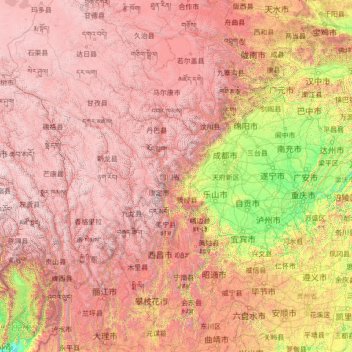
Name: Sichuan topographic map, elevation, terrain.

Location: Sichuan, China (26.04817 97.34738 34.31471 108.54267)

Average elevation: 2,522 m

Minimum elevation: 140 m

Maximum elevation: 6,536 m

Other topographic maps

Click on a map to view its topography, its elevation and its terrain.

Tibet

China

The Tibet Autonomous Region is located on the Tibetan Plateau, the highest region on Earth. In northern Tibet elevations reach an average of over 4,572 metres (15,000 ft). Mount Everest is located on Tibet's border with Nepal.

Average elevation: 3,040 m

Dalad

China > Inner Mongolia

Average elevation: 1,276 m

Nige

China > Sichuan > Chaluo

Average elevation: 3,845 m

Kanggar

China > Sichuan > Kangding

Average elevation: 4,123 m

Mount Kailash

China > Tibet > Purang County > Darchen

Mount Kailash (also Kailasa; Kangrinboqê or Gang Rinpoche; Standard Tibetan: གངས་རིན་པོ་ཆེ; simplified Chinese: 冈仁波齐峰; traditional Chinese: 岡仁波齊峰; pinyin: Gāngrénbōqí Fēng; Sanskrit: कैलास, IAST: Kailāsa) is a mountain in Ngari Prefecture, Tibet…

Average elevation: 5,748 m

Danfeng

China > Shaanxi

Average elevation: 989 m

Huangzhou District

China > Hubei

Average elevation: 24 m

Huangshan District

China > Anhui > Huangshan

Average elevation: 405 m

黄山

China > Shandong > Tai'an

Average elevation: 94 m

Shangbaishui

China > Yunnan > Yulong Nakhi Autonomous County > Daju

Average elevation: 2,990 m

黄山

China > Shandong > Rizhao

Average elevation: 72 m

Meizhou Island

China > Fujian

Average elevation: 3 m

Shanghai

China > Shanghai

The golden age of Shanghai began with its elevation to municipality after it was separated from Jiangsu on 7 July 1927. This new Chinese municipality covered an area of 494.69 km2 (191.0 sq mi), including the modern-day districts of Baoshan, Yangpu, Zhabei, Nanshi, and Pudong, but excluded the foreign…

Average elevation: 5 m

Zigong

China > Sichuan

Average elevation: 392 m

Lihuo

China > Guangxi > Naliang Township

Average elevation: 233 m

Daqing City

China > Heilongjiang

Average elevation: 152 m

Bagui

China > Guangxi > Tianlin County

Average elevation: 574 m

Inner Mongolia

China

Inner Mongolia largely consists of the northern side of the North China Craton, a tilted and sedimented Precambrian block. In the extreme southwest is the edge of the Tibetan Plateau where the autonomous region's highest peak, Main Peak in the Helan Mountains reaches 3,556 metres (11,670 ft), and is still…

Average elevation: 891 m

Golog

China > Qinghai

The lay of the land of the prefecture is largely determined by the Amne Machin mountain range (max elevation 6,282 m), which runs in the general northwest- to-southeast direction across the entire prefecture, and beyond. The existence of the ridge results in one of the great bends of the Yellow River, which…

Average elevation: 4,030 m

Gansu

China

Gansu generally has a semi-arid to arid continental climate (Köppen BSk or BWk) with warm to hot summers and cold to very cold winters, although diurnal temperature ranges are often so large that maxima remain above 0 °C (32 °F) even in winter. However, due to extreme altitude, some areas of Gansu exhibit a…

Average elevation: 2,260 m

Zhejiang

China

Zhejiang consists mostly of hills, which account for about 70% of its total area, with higher altitudes towards the south and the west. Zhejiang also has a longer coastline than any other mainland province of China. The Qiantang River runs through the province, from which it derives its name. Included in the…

Average elevation: 223 m

Ningxia

China

Average elevation: 1,565 m

Jiangsu

China

Jiangsu is flat, with plains covering 68 percent of its total area (water covers another 18 percent). Most of the province stands not more than 50 meters (160 ft) above sea level. Jiangsu also has a well-developed irrigation system, which earned it (especially the southern half) the moniker of traditional…

Average elevation: 24 m

Macau

China > Macau > São Lourenço

Average elevation: 17 m

Hubei

China

Average elevation: 363 m

Fujian

China

The province is mostly mountainous and is traditionally said to be "eight parts mountain, one part water, and one part farmland" (八山一水一分田). The northwest is higher in altitude, with the Wuyi Mountains forming the border between Fujian and Jiangxi. It is the most forested provincial-level…

Average elevation: 302 m

Nanjing City

China > Jiangsu

There are mainly two types of soil in Nanjing: zonal soil and cultivated soil. The zonal soil is yellow-brown soil in the northern and central areas of Nanjing, and red soil in the southern part of the border with Anhui. The cultivated soil formed by human-made farming is mainly paddy soil, and there are some…

Average elevation: 28 m

Maya

China > Anhui > Chizhou

Average elevation: 86 m

Tianjin

China

There is 153 km (95 mi) of coastline and 1,137.48 kilometers (706.80 mi) of land border. It lies at the northern end of the Grand Canal of China, which connects with the Yellow River and Yangtze River. The municipality is generally flat, and swampy near the coast, but hilly in the far north, where the Yan…

Average elevation: 64 m

Guizhou

China

Guizhou is a mountainous province, with its higher altitudes in the west and centre. It lies at the eastern end of the Yungui Plateau. Demographically, it is one of China's most diverse provinces. Minority groups account for more than 37% of the population, including sizable populations of the Miao, Bouyei,…

Average elevation: 914 m

Baotou City

China > Inner Mongolia

Baotou features a cold semi-arid climate (Köppen BSk), marked by long, cold and very dry winters, hot, somewhat humid summers, and strong winds, especially in spring. Temperatures often fall below −15 °C (5 °F) in winter and rise above 30 °C (86 °F) in summer. The annual precipitation is approximately…

Average elevation: 1,316 m

Tai'an

China > Shandong

Average elevation: 161 m

Baoding City

China > Hebei

Average elevation: 338 m

19

China > Hong Kong > Hong Kong Island

Average elevation: 143 m

Liaocheng

China > Shandong

Average elevation: 46 m

Qinhuangdao

China > Hebei

Average elevation: 143 m

Baihuahu

China > Guizhou > Guiyang

Average elevation: 1,255 m

Dalin

China > Inner Mongolia > Tongliao City

Average elevation: 161 m

Jianzhu Subdistrict

China > Heilongjiang > Harbin

Average elevation: 163 m

Datong City

China > Shanxi

Datong is a prefecture-level city in northern Shanxi Province in the People's Republic of China. It is located in the Datong Basin at an elevation of 1,040 metres (3,410 ft) and borders Inner Mongolia to the north and west and Hebei to the east. As of the 2020 census, it had a population of 3,105,591 of whom…

Average elevation: 1,339 m

Xinwu District

China > Jiangsu

Average elevation: 7 m

Lukou District

China > Hunan

Average elevation: 113 m

Lidong

China > Guangdong Province > Yunan County

Average elevation: 277 m

Shanghai

China

The golden age of Shanghai began with its elevation to municipality after it was separated from Jiangsu on 7 July 1927. This new Chinese municipality covered an area of 494.69 km2 (191.0 sq mi), including the modern-day districts of Baoshan, Yangpu, Zhabei, Nanshi, and Pudong, but excluded the foreign…

Average elevation: 3 m

Chongchuan District

China > Jiangsu

Average elevation: 3 m

Bagua Island

China > Jiangsu > Nanjing City

Average elevation: 7 m

Beijing

China > Beijing

Beijing is situated at the northern tip of the roughly triangular North China Plain, which opens to the south and east of the city. Mountains to the north, northwest and west shield the city and northern China's agricultural heartland from the encroaching desert steppes. The northwestern part of the…

Average elevation: 47 m

Municipality of Macau

China > Macau

Average elevation: 14 m

Nanyang

China > Henan

Average elevation: 325 m

Xing'an County

China > Guangxi

Average elevation: 548 m