
Pipiwai topographic map
Interactive map
Click on the map to display elevation.
About this map
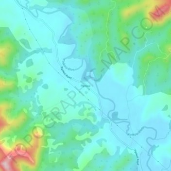
Name: Pipiwai topographic map, elevation, terrain.
Location: Pipiwai, Whangarei District, Northland, New Zealand (-35.63994 173.99787 -35.59994 174.03787)
Average elevation: 88 m
Minimum elevation: 27 m
Maximum elevation: 341 m
Other topographic maps
Click on a map to view its topography, its elevation and its terrain.
Whangārei
New Zealand > Northland > Whangarei District
Whangārei, Whangarei District, Northland, 0110, New Zealand
Average elevation: 96 m
Waipu Cove
New Zealand > Northland > Whangarei District
Waipu Cove, Whangarei District, Northland, New Zealand
Average elevation: 33 m
Oakura Bay
New Zealand > Northland > Whangarei District > Ōakura
Oakura Bay, Ōakura, Whangarei District, Northland, New Zealand
Average elevation: 20 m
Ngunguru
New Zealand > Northland > Whangarei District
Ngunguru, Whangarei District, Northland, New Zealand
Average elevation: 34 m
Parua Bay
New Zealand > Northland > Whangarei District
Parua Bay, Whangarei District, Northland, 0174, New Zealand
Average elevation: 35 m
Taiharuru
New Zealand > Northland > Whangarei District
Taiharuru, Whangarei District, Northland, 0192, New Zealand
Average elevation: 8 m
Tutukaka
New Zealand > Northland > Whangarei District
Tutukaka, Whangarei District, Northland, New Zealand
Average elevation: 36 m
One Tree Point
New Zealand > Northland > Whangarei District
One Tree Point, Whangarei District, Northland, 0118, New Zealand
Average elevation: 12 m
Waipū
New Zealand > Northland > Whangarei District
Waipū, Whangārei District, Northland, 0510, New Zealand
Average elevation: 19 m
Nukutawhiti
New Zealand > Northland > Whangarei District
Nukutawhiti, Whangarei District, Northland, New Zealand
Average elevation: 117 m
Ruakaka
New Zealand > Northland > Whangarei District
Ruakaka, Whangarei District, Northland, 0116, New Zealand
Average elevation: 15 m
Matapouri
New Zealand > Northland > Whangarei District > Matapouri
Matapouri, Whangarei District, Northland, New Zealand
Average elevation: 18 m
Ruatangata West
New Zealand > Northland > Whangarei District > Ruatangata West
Ruatangata West, Whangarei District, Northland, New Zealand
Average elevation: 152 m
Mount Parihaka
New Zealand > Northland > Whangarei District > Whangarei
Mount Parihaka, Whangarei, Whangarei District, Northland, NTL 0110, New Zealand
Average elevation: 81 m
Maungatapere
New Zealand > Northland > Whangarei District
Maungatapere, Whangarei District, Northland, 0170, New Zealand
Average elevation: 144 m
Whananaki
New Zealand > Northland > Whangarei District
Whananaki, Whangārei District, Northland, 0181, New Zealand
Average elevation: 17 m
Mount Manaia
New Zealand > Northland > Whangarei District > Taurikura
Mount Manaia, Taurikura, Whangarei District, Northland, 0174, New Zealand
Average elevation: 81 m
Whangarei Heads
New Zealand > Northland > Whangarei District > Whangarei Heads
Whangarei Heads, Whangarei District, Northland, 0174, New Zealand
Average elevation: 52 m
Wairua River
New Zealand > Northland > Whangarei District
Wairua River, Whangārei District, Northland, New Zealand
Average elevation: 117 m