
Taieri Mouth topographic map
Interactive map
Click on the map to display elevation.
About this map
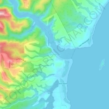
Name: Taieri Mouth topographic map, elevation, terrain.
Location: Taieri Mouth, Clutha District, Otago, New Zealand (-46.07412 170.17234 -46.03412 170.21234)
Average elevation: 46 m
Minimum elevation: -7 m
Maximum elevation: 219 m
Other topographic maps
Click on a map to view its topography, its elevation and its terrain.
Lawrence
New Zealand > Otago > Clutha District
Lawrence, Clutha District, Otago, 9532, New Zealand
Average elevation: 163 m
Waitahuna Hill
New Zealand > Otago > Clutha District
Waitahuna Hill, Clutha District, Otago, New Zealand
Average elevation: 537 m
Beaumont
New Zealand > Otago > Clutha District
Beaumont, Clutha District, Otago, New Zealand
Average elevation: 122 m
Waihola Hill
New Zealand > Otago > Clutha District
Waihola Hill, Clutha District, Otago, 9243, New Zealand
Average elevation: 55 m
Balclutha
New Zealand > Otago > Clutha District
Balclutha, Clutha District, Otago, 9230, New Zealand
Average elevation: 40 m
Owaka
New Zealand > Otago > Clutha District
Owaka, Clutha District, Otago, 9535, New Zealand
Average elevation: 27 m
Clinton
New Zealand > Otago > Clutha District
Clinton, Clutha District, Otago, 9534, New Zealand
Average elevation: 153 m
Tokoiti
New Zealand > Otago > Clutha District > Milton > Tokoiti
Tokoiti, Milton, Clutha District, Otago, 9220, New Zealand
Average elevation: 50 m
Kapiti
New Zealand > Otago > Clutha District
Kapiti, Clutha District, Otago, 9291, New Zealand
Average elevation: 92 m