Geolocate

Malungon topographic map

Interactive map

Click on the map to display elevation.

About this map

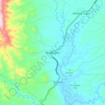
Name: Malungon topographic map, elevation, terrain.

Location: Malungon, Sarangani, Soccsksargen, 9503, Philippines (6.33568 125.22807 6.41568 125.30807)

Average elevation: 218 m

Minimum elevation: 99 m

Maximum elevation: 728 m

Other topographic maps

Click on a map to view its topography, its elevation and its terrain.

Buayan River

Philippines > Sarangani > Malungon

Average elevation: 149 m

Malapatan

Philippines > Sarangani

Average elevation: 86 m

Glan

Philippines > Sarangani

Average elevation: 45 m

Roque Adarna

Philippines > Sarangani

Average elevation: 74 m

Maitum

Philippines > Sarangani

Average elevation: 48 m

Malandag

Philippines > Sarangani

Average elevation: 183 m

Domolok

Philippines > Sarangani

Average elevation: 47 m

Bukay-eel

Philippines > Sarangani

Average elevation: 689 m

Alabel

Philippines > Sarangani

Average elevation: 63 m

Kawas

Philippines > Sarangani > Kawas

Average elevation: 14 m

Nop Proper

Philippines > Sarangani > Nop Proper

Average elevation: 117 m