
Malandag topographic map
Interactive map
Click on the map to display elevation.
About this map
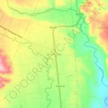
Name: Malandag topographic map, elevation, terrain.
Location: Malandag, Sarangani, Soccsksargen, 9503, Philippines (6.28840 125.23225 6.32840 125.27225)
Average elevation: 183 m
Minimum elevation: 81 m
Maximum elevation: 293 m
Other topographic maps
Click on a map to view its topography, its elevation and its terrain.
Buayan River
Philippines > Sarangani > Malungon
Buayan River, Malungon, Sarangani, Soccsksargen, 9503, Philippines
Average elevation: 149 m
Malungon
Malungon, Sarangani, Soccsksargen, 9503, Philippines
Average elevation: 218 m
Bukay-eel
Bukay-eel, Sarangani, Soccsksargen, Philippines
Average elevation: 689 m
Nop Proper
Philippines > Sarangani > Nop Proper
Nop Proper, Sarangani, Soccsksargen, 9501, Philippines
Average elevation: 117 m
Kawas
Philippines > Sarangani > Kawas
Kawas, Sarangani, Soccsksargen, 9501, Philippines
Average elevation: 14 m