
Bay of Islands-Whangaroa Community topographic map
Interactive map
Click on the map to display elevation.
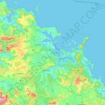
Bay of Islands-Whangaroa Community topographic map, elevation, terrain
About this map
Name: Bay of Islands-Whangaroa Community topographic map, elevation, terrain.
Average elevation: 91 m
Minimum elevation: 0 m
Maximum elevation: 700 m
Routes: Far North District GPS tracks, routes, trails, hikes
Other topographic maps
Click on a map to view its topography, its elevation and its terrain.
Whirinaki
New Zealand > Northland > Far North District > Kaikohe-Hokianga Community
Average elevation: 71 m
Broadwood
New Zealand > Northland > Far North District > Kaikohe-Hokianga Community
Average elevation: 144 m
Fern Hill
New Zealand > Northland > Far North District > Kaikohe-Hokianga Community
Average elevation: 122 m
Rangitoto
New Zealand > Northland > Far North District > Kaikohe-Hokianga Community
Average elevation: 24 m
Pakaraka
New Zealand > Northland > Far North District > Bay of Islands-Whangaroa Community
Average elevation: 92 m
Uruti Bay
New Zealand > Northland > Far North District > Bay of Islands-Whangaroa Community
Average elevation: 21 m
Haruru
New Zealand > Northland > Far North District > Bay of Islands-Whangaroa Community
Average elevation: 43 m
Taumarere
New Zealand > Northland > Far North District > Bay of Islands-Whangaroa Community > Kawakawa
Average elevation: 53 m
Puponga Point
New Zealand > Northland > Far North District > Te Hiku Community
Average elevation: 13 m
Matangirau
New Zealand > Northland > Far North District > Bay of Islands-Whangaroa Community
Average elevation: 16 m
Kerikeri
New Zealand > Northland > Far North District > Bay of Islands-Whangaroa Community
Average elevation: 76 m
Opononi
New Zealand > Northland > Far North District > Kaikohe-Hokianga Community
Average elevation: 51 m
Rotokakahi
New Zealand > Northland > Far North District > Kaikohe-Hokianga Community
Average elevation: 90 m
Kaeo River
New Zealand > Northland > Far North District > Bay of Islands-Whangaroa Community
Average elevation: 121 m
Rawhiti
New Zealand > Northland > Far North District > Bay of Islands-Whangaroa Community
Average elevation: 45 m
Utakura River
New Zealand > Northland > Far North District > Kaikohe-Hokianga Community
Average elevation: 124 m
Waiparera Stream
New Zealand > Northland > Far North District > Te Hiku Community
Average elevation: 5 m
Runaruna
New Zealand > Northland > Far North District > Kaikohe-Hokianga Community
Average elevation: 81 m
Waitangi
New Zealand > Northland > Far North District > Bay of Islands-Whangaroa Community
Average elevation: 15 m
Kaikohe
New Zealand > Northland > Far North District > Kaikohe-Hokianga Community
Average elevation: 218 m
Haruru Falls
New Zealand > Northland > Far North District > Bay of Islands-Whangaroa Community > Haruru
Average elevation: 34 m
Taupo Bay
New Zealand > Northland > Far North District > Bay of Islands-Whangaroa Community
Average elevation: 71 m
Tauwhare
New Zealand > Northland > Far North District > Kaikohe-Hokianga Community
Average elevation: 281 m
Coopers Beach
New Zealand > Northland > Far North District > Te Hiku Community
Average elevation: 42 m
Onewhero Bay
New Zealand > Northland > Far North District > Bay of Islands-Whangaroa Community
Average elevation: 18 m
Kaeo
New Zealand > Northland > Far North District > Bay of Islands-Whangaroa Community
Average elevation: 75 m
Paihia
New Zealand > Northland > Far North District > Bay of Islands-Whangaroa Community
Average elevation: 27 m
Okaihau
New Zealand > Northland > Far North District > Kaikohe-Hokianga Community
Average elevation: 107 m