Geolocate

Culverden topographic map

Interactive map

Click on the map to display elevation.

About this map

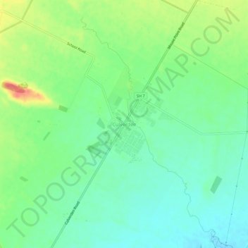
Name: Culverden topographic map, elevation, terrain.

Location: Culverden, Hurunui District, Canterbury, 7345, New Zealand (-42.79266 172.82930 -42.75266 172.86930)

Average elevation: 183 m

Minimum elevation: 162 m

Maximum elevation: 221 m

Routes: Hurunui District GPS tracks, routes, trails, hikes

Other topographic maps

Click on a map to view its topography, its elevation and its terrain.

Hanmer Springs

New Zealand > Canterbury > Hurunui District

The Jacks Pass – Clarence River – Jollies Pass Loop is a 25 kilometer loop which is not technically challenging however it takes between two to four hours to complete. It can be ridden in either direction: West over Jacks Pass (869m) or East over Jollies Pass (850m). As the entire ride is at high elevation…

Average elevation: 490 m

Greta Valley

New Zealand > Canterbury > Hurunui District

Average elevation: 235 m

Gore Bay

New Zealand > Canterbury > Hurunui District

Average elevation: 54 m

Masons Flat

New Zealand > Canterbury > Hurunui District

Average elevation: 303 m

Waiau

New Zealand > Canterbury > Hurunui District

Average elevation: 167 m

Mount Lyford

New Zealand > Canterbury > Hurunui District

Average elevation: 1,242 m

Amberley

New Zealand > Canterbury > Hurunui District

Average elevation: 55 m

Leithfield

New Zealand > Canterbury > Hurunui District

Average elevation: 19 m

Mount Horrible

New Zealand > Canterbury > Hurunui District

Average elevation: 1,363 m

Waipara

New Zealand > Canterbury > Hurunui District

Average elevation: 74 m

Cheviot

New Zealand > Canterbury > Hurunui District

Average elevation: 93 m