
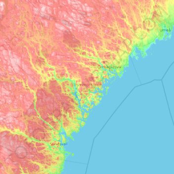
Västernorrland County topographic map
Interactive map
Click on the map to display elevation.
Västernorrland County topographic map, elevation, terrain
About this map
Name: Västernorrland County topographic map, elevation, terrain.
Location: Västernorrland County, Sweden (62.08721 14.78033 64.02743 19.60753)
Average elevation: 162 m
Minimum elevation: -3 m
Maximum elevation: 646 m
Other topographic maps
Click on a map to view its topography, its elevation and its terrain.
Södermalm
The name Södermalm (as Suthaermalm) is first mentioned in 1288 in a letter from Bishop Anund of Strängnäs. Until the early 17th century Södermalm was mainly a rural, agricultural area. Its first urban areas were planned and built in the mid 17th century, comprising a mixture of working class housing, such…
Average elevation: 22 m
Södertälje
Due to its topography and the fact that it is divided by a canal, it has been difficult to build good train connections in and through the city. Despite this, Södertälje is one of the largest railway hubs in Sweden. When the railway to Södertälje was commissioned, it was decided that the main line would…
Average elevation: 38 m
Karlskrona
When the city was founded in 1680, it was primarily thought of as a military city, with many defenses and fortifications exploiting the particular topography of the city. Some fortifications were located on the main island (Trossö) such as the Bastion Aurora, built at the beginning of the 18th century, but…
Average elevation: 25 m