
Enugu State topographic map
Interactive map
Click on the map to display elevation.
About this map
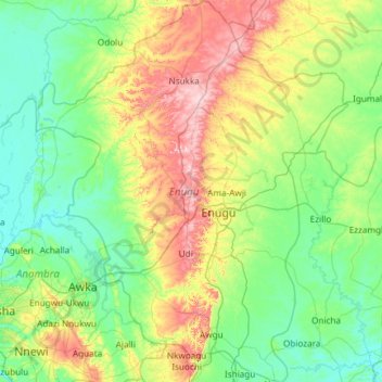
Name: Enugu State topographic map, elevation, terrain.
Location: Enugu State, Nigeria (5.92464 6.93167 7.10366 7.90340)
Average elevation: 145 m
Minimum elevation: 15 m
Maximum elevation: 583 m
Other topographic maps
Click on a map to view its topography, its elevation and its terrain.
Jos
Nigeria > Plateau State > Jos North
At an altitude of 1,217 m (3,993 ft) above sea level, Jos' climate is closer to temperate than that of the vast majority of Nigeria. Average monthly temperatures range from 21–25 °C (70–77 °F), and from mid-November to late January, night-time temperatures drop as low as 7 °C (45 °F). Hail sometimes…
Average elevation: 1,181 m
Abuja
Nigeria > Federal Capital Territory > Municipal Area Council
The elevation is 360 metres (1,180 ft).
Average elevation: 508 m