
Tararua District topographic map
Interactive map
Click on the map to display elevation.
About this map
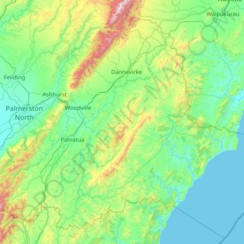
Name: Tararua District topographic map, elevation, terrain.
Location: Tararua District, Manawatū-Whanganui, New Zealand (-40.78246 175.47344 -39.99550 176.63280)
Average elevation: 246 m
Minimum elevation: -2 m
Maximum elevation: 1,537 m
Routes: Manawatu-Whanganui GPS tracks, routes, trails, hikes
Other topographic maps
Click on a map to view its topography, its elevation and its terrain.
Mount Tongariro
New Zealand > Manawatu-Whanganui > Ruapehu District
The high altitude and severe alpine climate between March and October allow snowfall in the winter (there are commercial ski-fields at neighbouring Mount Ruapehu) and rain can freeze, causing verglas; in contrast in the mid to late summer, the mountains can be bare apart from remnant patches of snow in…
Average elevation: 1,675 m
Taumarunui
New Zealand > Manawatu-Whanganui > Ruapehu District
Under the Köppen, Taumarunui has an Oceanic climate:(Cfb). Due to location, low altitude and Geography surroundings, Taumarunui is more liable to warm to hot summers than other central North Island centres and in winter Taumarunui is cold and frosty. Rainfall yearly is 1,449 mm (57.047244 in). Annual sunshine…
Average elevation: 245 m
Koriniti Pā / Ōtūkōpiri
New Zealand > Manawatu-Whanganui > Whanganui District
Average elevation: 208 m
National Park
New Zealand > Manawatu-Whanganui > Ruapehu District
Under the Köppen-Geiger climate classification, National Park has an oceanic climate (Cfb). February is the warmest month, with an average temperature of 14.8 °C, while July is the coldest month with an average temperature of 4.5 °C. Due to an altitude of 822 metres, winters are cold, and generally winter…
Average elevation: 820 m
Dannevirke
New Zealand > Manawatu-Whanganui > Tararua District
Dannevirke has an Oceanic climate, (Köppen:Cfb). Due its high altitude the summer temperatures are often cooler compared to other Eastern North Island towns, such as Masterton, Napier and Gisborne, while in winter Dannevirke can regularly experience frosts as in other parts of New Zealand. Snow is rare, the…
Average elevation: 221 m
Manawatu River
New Zealand > Manawatu-Whanganui
At the time of human arrival, the Manawatū Plains were covered with forest. Towards the foothills and the Manawatū Gorge grew black beech, turning into tawa forest at lower altitudes. Along the plains and terraces the forest was mixed podocarp and tōtara, changing to mixed tawa, tītoki, and māhoe in the…
Average elevation: 275 m
Waiouru
New Zealand > Manawatu-Whanganui > Ruapehu District
Because of its high altitude and close proximity to Mt Ruapehu, Waiouru's climate is cold throughout the year, unlike other North Island centres, and particularly cold when the wind blows from the mountain. The Desert Road is regularly closed in winter owing to heavy snowfalls. Waiouru's climate can be…
Average elevation: 817 m
Sunshine Settlement
New Zealand > Manawatu-Whanganui > Ruapehu District > Taumarunui
Average elevation: 214 m
Ohakune
New Zealand > Manawatu-Whanganui > Ruapehu District
Ohakune is located in the Ruapehu District and the Manawatū-Whanganui region, to the immediate south-west of the slopes of the Mount Ruapehu stratovolcano. The town is 25 kilometres (16 miles) west of Waiouru, 70 kilometres (43 miles) northeast of Whanganui, 287 kilometres (178 miles) north of Wellington and…
Average elevation: 619 m
Westmere Lake Wildlife Refuge
New Zealand > Manawatu-Whanganui > Whanganui District > Whanganui
Average elevation: 106 m
Palmerston North
New Zealand > Manawatu-Whanganui
Although the land Palmerston North is situated on is bounded by the lofty Ruahine and Tararua ranges in the east and south respectively, the city has a predominantly flat appearance. The occasional rise in elevation occurs further away from the river and is especially pronounced in the north and northeast, and…
Average elevation: 133 m