
Kanchanaburi Province topographic map
Interactive map
Click on the map to display elevation.
About this map
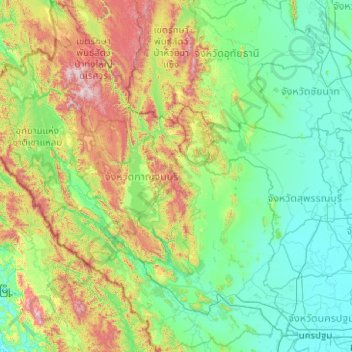
Name: Kanchanaburi Province topographic map, elevation, terrain.
Location: Kanchanaburi Province, Thailand (13.72614 98.18170 15.66301 99.89221)
Average elevation: 297 m
Minimum elevation: 0 m
Maximum elevation: 1,702 m
The province is in the west of Thailand, 129 km from Bangkok, and covers a total area of approximately 19,483 km2 (7,522 sq mi). It is the country's third largest province, after Nakhon Ratchasima and Chiang Mai. Topographically, it is covered with timber and evergreen forests. The total forest area is 12,002 km2 (4,634 sq mi) or 61.9 percent of provincial area. The district covers the source valleys of the rivers Kwae Yai and Kwae Noi ("River Kwai"), which merge at Kanchanaburi city to form the Mae Klong River.
Other topographic maps
Click on a map to view its topography, its elevation and its terrain.
Ban Na Pha Niat
Ban Na Pha Niat, Khao Noi, Wang Phong, Prachuap Khiri Khan Province, 77120, Thailand
Average elevation: 7 m
Ban Huai Pod
Ban Huai Pod, That, Loei Province, Thailand
Average elevation: 246 m
Khao Hua Chang
Thailand > Phatthalung Province
Khao Hua Chang, Phatthalung Province, Thailand
Average elevation: 206 m
Pattani
Pattani, Ru Samilae, Pattani Province, 94000, Thailand
Average elevation: 3 m
Patong
Thailand > Phuket Province > Kathu
Patong, Kathu, Phuket Province, 83159, Thailand
Average elevation: 123 m
Ban Nong Yai
Ban Nong Yai, Sa Kamphaeng Yai, Si Sa Ket Province, Thailand
Average elevation: 145 m
Damnoen Saduak
Thailand > Ratchaburi Province
Damnoen Saduak, Si Don Phai, Ratchaburi Province, 70130, Thailand
Average elevation: 5 m
homo erectus and mammoth park
homo erectus and mammoth park, Thung Phaya Thai Subdistrict, Ratchathewi District, Bangkok, 10400, Thailand
Average elevation: 7 m
Mekong River
Thailand > Nong Khai Province > Si Chiang Mai
Mekong River, Si Chiang Mai, Kong Nang, Nong Khai Province, Thailand
Average elevation: 170 m
Ban Pa Daet North
Thailand > Chiang Mai Province
Ban Pa Daet North, Pa Daet, Saraphi District, Chiang Mai Province, 50100, Thailand
Average elevation: 304 m
Ban Nong Kha Tae
Thailand > Chiang Mai Province
Ban Nong Kha Tae, Mueang Ngai, Chiang Mai Province, Thailand
Average elevation: 1,250 m
Maha Phram Subdistrict Municipality
Thailand > Phra Nakhon Si Ayutthaya Province > Bang Ban District
Maha Phram Subdistrict Municipality, Bang Ban District, Phra Nakhon Si Ayutthaya Province, 13250, Thailand
Average elevation: 5 m
Phetchabun
Thailand > Phetchabun Province
Phetchabun, Phetchabun Province, 67000, Thailand
Average elevation: 120 m
Phuket
Thailand > Phuket Province > Phuket
Phuket, Phuket Province, 83000, Thailand
Average elevation: 22 m
Haad Chaloklum
Thailand > Surat Thani Province > Moo 7
Haad Chaloklum, Baan Chaloklum, Moo 7, Surat Thani Province, Thailand
Average elevation: 82 m
Phetchaburi Province
Thailand > Phetchaburi Province
Phetchaburi Province, Thailand
Average elevation: 105 m
Ban Nong Na Dam
Thailand > Phichit Province > Ban Nong Na Dam
Ban Nong Na Dam, Phichit Province, Thailand
Average elevation: 37 m
Ban Chang
Thailand > Rayong Province > Ban Chang
Ban Chang, Rayong Province, TUNG PONG, Thailand
Average elevation: 58 m
Ban Khun Khlang
Thailand > Chiang Mai Province > Ban Khun Khlang
Ban Khun Khlang, Chiang Mai Province, Thailand
Average elevation: 1,392 m
Ban Mai Subdistrict
Thailand > Nonthaburi Province > Ban Mai Subdistrict
Ban Mai Subdistrict, Pak Kret District, Nonthaburi Province, 11120, Thailand
Average elevation: 4 m
Ko Samui
Thailand > Surat Thani Province
Ko Samui, Surat Thani Province, Thailand
Average elevation: 75 m
Doi Pha Hom Pok National Park
Thailand > Chiang Mai Province > Ban Huey Mak Liam
Doi Pha Hom Pok National Park, ชม.3015, Ban Huey Mak Liam, Chiang Mai Province, Thailand
Average elevation: 847 m
Ban Khok
Thailand > Si Sa Ket Province > Ban Khok
Ban Khok, Si Sa Ket Province, Thailand
Average elevation: 147 m
Pak Nam
Thailand > Suphan Buri Province > Pak Nam
Pak Nam, Suphan Buri Province, Thailand
Average elevation: 14 m
Khao luang
Thailand > Nakhon Si Thammarat Province > Nakhon Si Thammarat
Khao luang, Nakhon Si Thammarat, Nakhon Si Thammarat Province, Thailand
Average elevation: 1,286 m
Ban Luang
Thailand > Lampang Province > Ban Luang
Ban Luang, Lampang Province, Thailand
Average elevation: 383 m