
Steele County topographic map
Interactive map
Click on the map to display elevation.
About this map
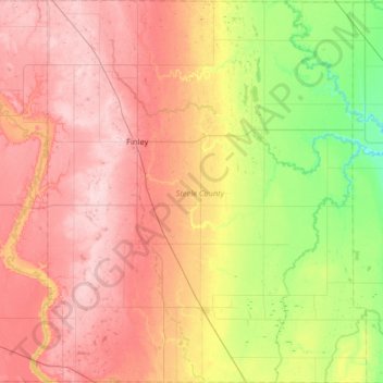
Name: Steele County topographic map, elevation, terrain.
Location: Steele County, North Dakota, United States (47.23935 -97.98782 47.67418 -97.45042)
Average elevation: 390 m
Minimum elevation: 296 m
Maximum elevation: 480 m
Other topographic maps
Click on a map to view its topography, its elevation and its terrain.
Carrington
United States > North Dakota > Foster County
Carrington, Foster County, North Dakota, 58421, United States
Average elevation: 484 m
Glenfield
United States > North Dakota > Foster County
Glenfield, Foster County, North Dakota, United States
Average elevation: 457 m
Rocklake
United States > North Dakota > Towner County
Rocklake, Towner County, North Dakota, United States
Average elevation: 471 m
Slope County
Slope County, North Dakota, United States
Average elevation: 860 m
Lake Ashtabula
United States > North Dakota > Barnes County
Lake Ashtabula, Barnes County, North Dakota, United States
Average elevation: 423 m
Regent
United States > North Dakota > Hettinger County > Regent
Regent, Hettinger County, North Dakota, United States
Average elevation: 755 m
Kindred
United States > North Dakota > Kindred
Kindred, Cass County, North Dakota, United States
Average elevation: 288 m
McKenzie County
McKenzie County, North Dakota, United States
Average elevation: 681 m
Balfour
United States > North Dakota > McHenry County
Balfour, McHenry County, North Dakota, United States
Average elevation: 488 m