Geolocate

Johor topographic map

Interactive map

Click on the map to display elevation.

About this map

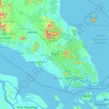
Name: Johor topographic map, elevation, terrain.

Location: Johor, Malaysia (1.19550 102.34749 2.83464 104.75120)

Average elevation: 31 m

Minimum elevation: -3 m

Maximum elevation: 1,069 m

Other topographic maps

Click on a map to view its topography, its elevation and its terrain.

Kuala Langat

Malaysia > Selangor

Average elevation: 6 m

Kota Tinggi

Malaysia > Johor

Average elevation: 29 m

Batu Kawa

Malaysia > Sarawak > Kuching

Average elevation: 9 m

Kajang Municipal Council

Malaysia > Selangor

Average elevation: 198 m

Mount Kinabalu

Malaysia > Sabah > Ranau

Mount Kinabalu (Dusun: Gayo Ngaran or Nulu Nabalu, Malay: Gunung Kinabalu) is the highest mountain in Borneo and Malaysia. With an elevation of 4,095 metres (13,435 ft), it is the third-highest peak of an island on Earth, the 28th highest peak in Southeast Asia, and 20th most prominent mountain in the world.…

Average elevation: 3,567 m

Kluang

Malaysia > Johor

Average elevation: 54 m

Perak

Malaysia

In 1959, a British artillery officer stationed at an inland army base during the Malayan Emergency discovered the Tambun rock art, identified by archaeologists as the largest rock art site in the Malay Peninsula. Most of the paintings are located high above the cave floor, at an elevation of 6–10 metres…

Average elevation: 251 m

Kundasang

Malaysia > Sabah > Ranau

Average elevation: 1,279 m

Pekan Nabalu

Malaysia > Sabah > Kota Belud

Average elevation: 761 m

Genting

Malaysia > Sabah > Sandakan District

Average elevation: 26 m

Bukit Tinggi

Malaysia > Pahang

Average elevation: 108 m

Miri

Malaysia > Sarawak > Miri

Average elevation: 9 m

Jempol

Malaysia > Negeri Sembilan

Average elevation: 79 m

Muar

Malaysia > Johor

Average elevation: 26 m

Sungai Benus

Malaysia > Pahang > Bentong

Average elevation: 512 m

Keningau

Malaysia > Sabah

Average elevation: 520 m

Skudai

Malaysia > Johor > Iskandar Puteri

Average elevation: 29 m

Sabah

Malaysia

The jungles of Sabah host a diverse array of plant and animal species. Most of Sabah's biodiversity is located in the forest reserve areas, which formed half of its total landmass of 7.34 million hectares. Its forest reserve are part of the 20 million hectares equatorial rainforests demarcated under the "Heart…

Average elevation: 115 m

Tambunan

Malaysia > Sabah > Tambunan

Tambunan (Malay: Pekan Tambunan) is the capital of the Tambunan District in the Interior Division of Sabah, Malaysia. Its population was estimated to be around 35,667 in 2010. It is located 80 kilometres east of the state capital, Kota Kinabalu (to which is connected by the Kota Kinabalu-Tambunan-Keningau…

Average elevation: 697 m

Kulai

Malaysia > Johor

Average elevation: 44 m

Plentong

Malaysia > Johor

Average elevation: 27 m

Terengganu

Malaysia

Terengganu is situated in eastern Peninsular Malaysia, and is bordered in the northwest by Kelantan, the southwest by Pahang, and the east by the South China Sea. The state has a total area of 13,035 km2 (5,033 sq mi). Its topographical profile ranges from relatively level on the coastal east and gradually…

Average elevation: 127 m

Iskandar Puteri

Malaysia > Johor

Average elevation: 26 m

George Town

Malaysia > Penang

Average elevation: 56 m

Kota Belud

Malaysia > Sabah

Average elevation: 41 m

Kota Kinabalu

Malaysia > Sabah

Average elevation: 86 m

Kuala Lumpur

Malaysia

Located in the centre of Selangor state, Kuala Lumpur was a territory of Selangor State Government. In 1974, Kuala Lumpur was split off from Selangor to form the first Federal Territory governed directly by the Malaysian federal government. Its location in the most developed state on the west coast of…

Average elevation: 80 m

Gunung Inas

Malaysia > Kedah

Average elevation: 1,086 m

Pulau Singa Besar

Malaysia > Kedah

Average elevation: 26 m

Raub

Malaysia > Pahang

Average elevation: 218 m

Labuan

Malaysia

Average elevation: 1 m

Tanah Merah

Malaysia > Kelantan

Average elevation: 95 m

Kulai

Malaysia > Johor

Average elevation: 40 m

Johor Bahru

Malaysia > Johor

Average elevation: 28 m

Johor Bahru

Malaysia > Johor

Average elevation: 27 m

Batu Pahat

Malaysia > Johor

Average elevation: 19 m

Penang

Malaysia

Penang Island is irregularly shaped, with a hilly and mostly forested interior; its coastal plains are narrow, the most extensive of which is at the northeastern cape. With a height of 833 m (2,733 ft), Penang Hill, at the centre of the island, is the tallest point within Penang. From a small settlement at the…

Average elevation: 18 m

Selangor

Malaysia

Average elevation: 90 m

Tumpat

Malaysia > Kelantan

Average elevation: 5 m

Pulau Mantanani Besar

Malaysia > Sabah

Average elevation: 2 m

Jerantut

Malaysia > Pahang > Jerantut

Average elevation: 74 m

Perlis

Malaysia > Perlis

Average elevation: 50 m

Ipoh

Malaysia > Perak > Ipoh

Average elevation: 205 m

Shah Alam

Malaysia > Selangor

Located in Klang Valley, Shah Alam topography is mostly flat, except in the northern part of the city where it features a prominent rolling hill.

Average elevation: 28 m

Paku

Malaysia > Sarawak > Kuching > Paku

Average elevation: 48 m

Negeri Sembilan

Malaysia > Negeri Sembilan

Average elevation: 92 m

Bukit Raya

Malaysia > Sarawak > Sri Aman

Average elevation: 130 m

Malacca

Malaysia

The state of Malacca covers an area of 1,664 km2 (642 sq mi). It sits upon the southwestern coast of the Malay Peninsula opposite Sumatra, with the state of Negeri Sembilan to the north and west and Johor to the east. Malacca is situated roughly two-thirds of the way down the west coast, 148 km (92 mi) south…

Average elevation: 26 m

Kelantan

Malaysia

Average elevation: 359 m