
Make a donation
Sabah topographic map
Click on the map to display elevation.
Make a donation
Sabah
The jungles of Sabah host a diverse array of plant and animal species. Most of Sabah's biodiversity is located in the forest reserve areas, which formed half of its total landmass of 7.34 million hectares. Its forest reserve are part of the 20 million hectares equatorial rainforests demarcated under the "Heart of Borneo" initiative. The forests surrounding the river valley of Kinabatangan River is the largest forest-covered floodplain in Malaysia. The Crocker Range National Park is the largest national park in the state, covering an area of 139,919 hectares. Most of the park area are covered in dense forest and important as a water catchment area with its headwater connecting to five major rivers in the west coast area. Kinabalu National Park was inscribed as a World Heritage Site by UNESCO in 2000 for its richness in plant diversity combined with its unique geological, topographical, and climatic conditions. The park hosts more than 4,500 species of flora and fauna, including 326 bird and around 100 mammal species along with over 110 land snail species.
Make a donation
About this map
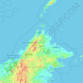
Name: Sabah topographic map, elevation, terrain.
Location: Sabah, Malaysia (3.90269 113.59024 8.38015 119.46996)
Average elevation: 115 m
Minimum elevation: -5 m
Maximum elevation: 3,963 m
Make a donation
Other topographic maps
Click on a map to view its topography, its elevation and its terrain.
Mount Kinabalu
Mount Kinabalu (Dusun: Gayo Ngaran or Nulu Nabalu, Malay: Gunung Kinabalu) is the highest mountain in Borneo and Malaysia. With an elevation of 4,095 metres (13,435 ft), it is the third-highest peak of an island on Earth, the 28th highest peak in Southeast Asia, and 20th most prominent mountain in the world.…
Average elevation: 3,567 m
Make a donation
Make a donation
Make a donation
Tambunan
Tambunan (Malay: Pekan Tambunan) is the capital of the Tambunan District in the Interior Division of Sabah, Malaysia. Its population was estimated to be around 35,667 in 2010. It is located 80 kilometres east of the state capital, Kota Kinabalu (to which is connected by the Kota Kinabalu-Tambunan-Keningau…
Average elevation: 697 m
Make a donation