
Canterbury topographic map
Interactive map
Click on the map to display elevation.
About this map
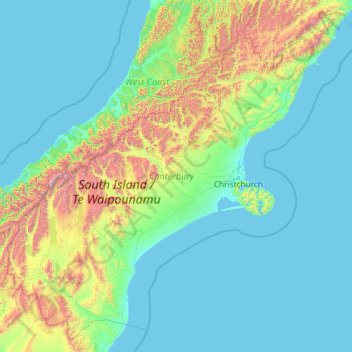
Name: Canterbury topographic map, elevation, terrain.
Location: Canterbury, New Zealand (-45.08093 169.54250 -41.90740 174.23901)
Average elevation: 357 m
Minimum elevation: -1 m
Maximum elevation: 3,454 m
New Zealand trails, hiking, mountain biking, running and outdoor activities
Other topographic maps
Click on a map to view its topography, its elevation and its terrain.
Auckland
The Auckland Volcanic Field has contributed greatly to the growth and prosperity of the Auckland Region since the area was settled by humans. Initially, the maunga (scoria cones) were occupied and established as pā (fortified settlements) by Māori due to the strategic advantage their elevation provided in…
Average elevation: 32 m
Wellington
New Zealand > Wellington > Wellington City
Averaging 2,055 hours of sunshine per year, the climate of Wellington is temperate marine, (Köppen: Cfb), generally moderate all year round with warm summers and mild winters, and rarely sees temperatures above 23 °C (73 °F) or below 4 °C (39 °F). The hottest recorded temperature in the city is 31.1 °C…
Average elevation: 85 m
Dunedin
The climate of Dunedin in general is temperate. The city is recognised as having a large number of microclimates and the weather conditions often vary between suburbs mostly due to the city's topographical layout. Under the Köppen climate classification, Dunedin features an oceanic climate. The city's climate…
Average elevation: 110 m
Hineteawa / Bowen Falls
New Zealand > Southland > Southland District > Fiordland Community
Average elevation: 232 m
Queenstown
New Zealand > Otago > Queenstown-Lakes District
The town is at a relatively low altitude for a ski and snowboarding centre, at 310 metres (1,020 ft) above sea level at the lake shore, but is nestled among mountains, most notably the scenic attraction of The Remarkables, to the town's southeast. Below the lake lies the deep Kawarau Gorge, and there are…
Average elevation: 592 m
Waimānu / Stirling Falls
New Zealand > Southland > Southland District > Fiordland Community
Average elevation: 423 m
Edendale
New Zealand > Southland > Southland District > Waihopai Toetoe Community
Average elevation: 41 m
Mount Cook
New Zealand > Mackenzie District
Aoraki / Mount Cook is the highest mountain in New Zealand. Its height, as of 2014, is listed as 3,724 metres (12,218 feet). It is situated in the Southern Alps, the mountain range that runs the length of the South Island. A popular tourist destination, it is also a favourite challenge for mountaineers. Aoraki…
Average elevation: 2,920 m
Clifden
New Zealand > Southland > Southland District > Tuatapere Te Waewae Community
Average elevation: 70 m
Wellington
New Zealand > Wellington > Wellington City
Averaging 2,055 hours of sunshine per year, the climate of Wellington is temperate marine, (Köppen: Cfb, Trewartha: Cflk), generally moderate all year round with warm summers and cool to mild winters, and rarely sees temperatures above 26 °C (79 °F) or below 4 °C (39 °F). The hottest recorded temperature…
Average elevation: 85 m
Oban
New Zealand > Southland > Southland District > Stewart Island / Rakiura Community
Average elevation: 23 m
Reefton
New Zealand > West Coast > Buller District
Located in the Inangahua Valley at an altitude of 194m, Reefton falls under the Köppen-Geiger climate classification of Cfb (Oceanic), though the town's sheltered inland location lends its climate less maritime influence than coastal areas; as such, Reefton has recorded both the extreme highest temperature of…
Average elevation: 310 m
Saint Arnaud Range
New Zealand > Marlborough > Marlborough District
The lower elevations are covered primarily in beech forests, while higher elevations (above about 5,000 feet) are alpine.
Average elevation: 1,249 m
Fairlie
New Zealand > Canterbury > Mackenzie District
Fairlie is a Mackenzie District service town (or township) located in the Canterbury region of the South Island of New Zealand. The estimated population was 960 as of June 2024. Being on state highway 8 between Christchurch (182 km, 2 hours 20 minutes drive) and Queenstown (300 km 3.5 hours drive), tourism is…
Average elevation: 317 m
Greytown
New Zealand > Wellington > South Wairarapa District > Greytown Community
Average elevation: 59 m
Te Tii Waitangi Marae
New Zealand > Northland > Far North District > Bay of Islands-Whangaroa Community > Paihia
Average elevation: 14 m