
Saskatchewan topographic map
Interactive map
Click on the map to display elevation.
About this map
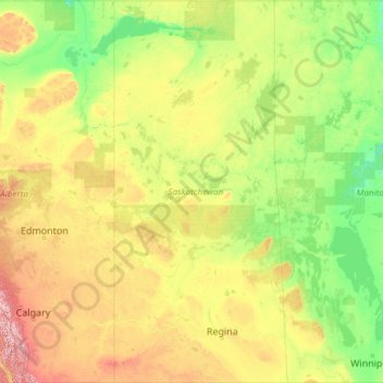
Name: Saskatchewan topographic map, elevation, terrain.
Location: Saskatchewan, Canada (48.99881 -110.00637 60.00003 -101.36191)
Average elevation: 511 m
Minimum elevation: 175 m
Maximum elevation: 3,227 m
Other topographic maps
Click on a map to view its topography, its elevation and its terrain.
Nemaiah Valley
Canada > British Columbia > Cariboo Regional District > Area J (West Chilcotin)
Average elevation: 1,270 m
Annapolis Valley
Canada > Nova Scotia > Municipality of the County of Kings > Auburn
Average elevation: 77 m
Havre-Aubert
Canada > Urban agglomeration of Les Îles-de-la-Madeleine > Les Îles-de-la-Madeleine
Average elevation: 3 m
Muskwa River
Canada > British Columbia > Peace River Regional District > Area B (Finlay Valley/Beatton Valley)
Average elevation: 1,496 m
Coyle Park
Canada > British Columbia > Regional District of Fraser-Fort George > Prince George
Average elevation: 625 m
Rubble Creek
Canada > British Columbia > Squamish-Lillooet Regional District > Area D (Elaho/Garibaldi)
Average elevation: 787 m
Mount Albert
Canada > British Columbia > Sunshine Coast Regional District > Area A (Egmont/Pender Harbour)
Average elevation: 1,937 m
Stoney Creek
Canada > British Columbia > Regional District of Central Kootenay > Area K (The Arrow Lakes)
Average elevation: 1,295 m
Appledale
Canada > British Columbia > Regional District of Central Kootenay > Area H (The Slocan Valley)
Average elevation: 707 m
Mount Hobson
Canada > British Columbia > Regional District of Bulkley-Nechako > Area D (Endako/Fort Fraser)
Average elevation: 1,079 m
Lyell Creek
Canada > British Columbia > Columbia-Shuswap Regional District > Area A (Kicking Horse/Kinbasket Lake)
Average elevation: 1,323 m
Nelson
Canada > British Columbia > Regional District of Central Kootenay > Nelson
Average elevation: 1,422 m
Mink Lake
Canada > British Columbia > Regional District of Bulkley-Nechako > Area E (Ootsa Lake/François Lake)
Average elevation: 898 m
Area G (Forster Creek/Mount Assiniboine)
Canada > British Columbia > Regional District of East Kootenay
Average elevation: 2,710 m
Courtenay
Canada > British Columbia > Comox Valley Regional District > Courtenay
Average elevation: 187 m
Glacier Bay
Canada > British Columbia > Area F (McConnell Creek/Hatzic Prairie)
Average elevation: 189 m
Middle Hill
Canada > British Columbia > North Coast Regional District > Area D (Graham Island)
Average elevation: 248 m
Garden Bay
Canada > British Columbia > Sunshine Coast Regional District > Area A (Egmont/Pender Harbour)
Average elevation: 79 m
Anse à Digue
Canada > Nova Scotia > Municipality of the County of Inverness > Chéticamp Island
Average elevation: 12 m
Rivervale
Canada > British Columbia > Regional District of Kootenay Boundary > Area B (Lower Columbia/Old Glory)
Average elevation: 610 m
Saint John
Canada > New Brunswick > Saint John
The topography surrounding Saint John is hilly; a result of the influence of two coastal mountain ranges which run along the Bay of Fundy – the St. Croix Highlands and the Caledonia Highlands. The soil throughout the region is extremely rocky with frequent granite outcrops. The coastal plain hosts numerous…
Average elevation: 44 m
Lac Castor Weather Radar
Canada > Quebec > Mont-Valin
Each had until 2018 a range of 256 km (159 mi) in radius around the site to detect reflectivity, 3 angles with a range of 128 km (80 mi), for detecting velocity pattern (Doppler effect), and an extra long range at low elevation angle of 240 km (150 mi) but strongly folded for latter same purpose.
Average elevation: 719 m
Bear Lake
Canada > British Columbia > Area G (Crooked River/Parsnip) > Bear Lake
Average elevation: 726 m
Peterborough
Canada > Ontario > Peterborough
Peterborough's topography is largely defined by land formations created by the receding Wisconsian glaciers 10,000–15,000 years ago. The South End and Downtown portions of the City sit on what was the bottom of the glacial Lake Peterborough—part of a glacial spillway created when glacial meltwaters from…
Average elevation: 235 m
Canmore
Elevation Place opened in April 2013 as Canmore's new recreation facility. Construction of the facility began in 2012 to replace the Canmore Recreation Centre (the community's old facility). The facility offers an 8-lane 25m lap pool, a world class climbing wall developed by Walltopia, two cardio rooms, a…
Average elevation: 1,565 m