
Santiago topographic map
Interactive map
Click on the map to display elevation.
About this map
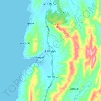
Name: Santiago topographic map, elevation, terrain.
Location: Santiago, Ilocos Sur, Ilocos Region, Philippines (17.25409 120.40532 17.33409 120.48532)
Average elevation: 53 m
Minimum elevation: 0 m
Maximum elevation: 247 m
Other topographic maps
Click on a map to view its topography, its elevation and its terrain.
Candon
Philippines > Ilocos Sur > Candon
Candon City is situated in the lower central portion of the Province of Ilocos Sur. It has a "C" shape with elevations ranging from 10 – 500 ft above sea level. The city is 346 kilometres (215 mi) from Metro Manila and 61 kilometres (38 mi) from Vigan City, the provincial capital.
Average elevation: 30 m
Vigan
Vigan is situated in a Quaternary Age sedimentary plain called the Vigan-Bantay Plain which is part of the Ilocos coastal plain. The Vigan-Bantay Plain is bounded on the east by a moderately rugged Miocene sediments consisting of interbedded sandstones and shale to very rugged Meta-volcanics and Meta sediment…
Average elevation: 34 m