
Hela topographic map
Interactive map
Click on the map to display elevation.
About this map
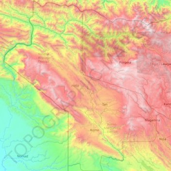
Name: Hela topographic map, elevation, terrain.
Location: Hela, Highlands Region, Papua New Guinea (-6.42065 142.06697 -4.94081 143.42361)
Average elevation: 1,577 m
Minimum elevation: 49 m
Maximum elevation: 3,781 m
Other topographic maps
Click on a map to view its topography, its elevation and its terrain.
Mount Hagen
Papua New Guinea > Western Highlands > Mount Hagen District
Mount Hagen (Tok Pisin: Maun Hagen) is the third largest city in Papua New Guinea, with a population of 46,250. It is the capital of the Western Highlands Province and is located in the large fertile Wahgi Valley in central mainland Papua New Guinea, at an elevation of 1,677 m (5,502 ft).
Average elevation: 1,904 m
New Guinea
A spine of east–west mountains, the New Guinea Highlands, dominates the geography of New Guinea, stretching over 1,600 km (1,000 mi) across the island, with many mountains over 4,000 m (13,100 ft). The western half of the island contains the highest mountains in Oceania, with its highest point, Puncak Jaya,…
Average elevation: 101 m
New Britain
Papua New Guinea > East New Britain
The island is part of two ecoregions. The New Britain-New Ireland lowland rain forests extend from sea level to 1000 meters elevation. The New Britain-New Ireland montane rain forests cover the mountains of New Britain above 1000 meters elevation.
Average elevation: 77 m