
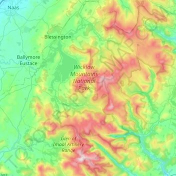
Wicklow Mountains National Park topographic map
Interactive map
Click on the map to display elevation.
About this map
Name: Wicklow Mountains National Park topographic map, elevation, terrain.
Average elevation: 324 m
Minimum elevation: 78 m
Maximum elevation: 919 m
Other topographic maps
Click on a map to view its topography, its elevation and its terrain.
Knockgriffin (Imokilly)
Knockgriffin (Imokilly), Midleton Rural, The Municipal District of East Cork, County Cork, Munster, Ireland
Average elevation: 20 m
Corleggy
Corleggy, Grilly ED, Cavan-Belturbet Municipal District, County Cavan, Ulster, Ireland
Average elevation: 52 m
Glencar
Glencar, Kenmare Municipal District, County Kerry, Munster, Ireland
Average elevation: 114 m
Queenstown No 1
Queenstown No 1, Municipal District of Cobh, County Cork, Munster, Ireland
Average elevation: 22 m
Benmore
Benmore, Westport-Belmullet Municipal District, County Mayo, Connacht, Ireland
Average elevation: 119 m
Kilburne
Kilburne, Waterford City Metropolitan District, County Waterford, Munster, X91 HH58, Ireland
Average elevation: 38 m
Cooraclare
Cooraclare, West Clare Municipal District, County Clare, Munster, Ireland
Average elevation: 34 m
Roundstone
Roundstone, Roundstone ED, Conamara Municipal District, County Galway, Connacht, H91 WP99, Ireland
Average elevation: 34 m
Blackstone
Blackstone, Killag ED, The Borough District of Wexford, County Wexford, Leinster, Ireland
Average elevation: 5 m
Lucan
Lucan, South Dublin, County Dublin, Leinster, K78 Y0F1, Ireland
Average elevation: 59 m
Greenlane
Greenlane, Finnoe, The Municipal District of Nenagh, County Tipperary, Munster, Ireland
Average elevation: 60 m
Marian Place
Marian Place, Portlaoise Rural ED, The Municipal District of Portlaoise, County Laois, Leinster, Ireland
Average elevation: 100 m
Tramore
Tramore, Waterford City Metropolitan District, County Waterford, Munster, Ireland
Average elevation: 41 m
The Borough District of Clonmel
The Borough District of Clonmel, County Tipperary, Munster, Ireland
Average elevation: 118 m
Clonmel
Ireland > County Dublin > Dublin
Clonmel, Ballymun E ED, Dublin, County Dublin, Leinster, Ireland
Average elevation: 57 m
Waterford
Ireland > County Waterford > Waterford
Waterford, County Waterford, Munster, Ireland
Average elevation: 33 m
Clonee
Ireland > County Meath > Clonee
Clonee, The Municipal District of Ratoath, County Meath, Leinster, D15 X036, Ireland
Average elevation: 66 m
Fanore
Ireland > County Clare > Fanore
Fanore, West Clare Municipal District, County Clare, Munster, Ireland
Average elevation: 87 m
Rathmore
Rathmore, Kilscoran ED, The Borough District of Wexford, County Wexford, Leinster, Ireland
Average elevation: 21 m
Rapla
Rapla, Nenagh Rural, The Municipal District of Nenagh, County Tipperary, Munster, Ireland
Average elevation: 78 m
Lambay Island
Lambay Island, Donabate ED, Fingal, County Dublin, Leinster, Ireland
Average elevation: 14 m
Ferns
Ireland > County Wexford > Ferns
Ferns, The Municipal District of Enniscorthy, County Wexford, Leinster, Y21 E8D5, Ireland
Average elevation: 60 m
Ballyguyroe South
Ireland > County Cork > Ballyguyroe South
Ballyguyroe South, Farahy, The Municipal District of Fermoy, County Cork, Munster, Ireland
Average elevation: 95 m
Blarney - Macroom
Ireland > County Cork > Blarney - Macroom
Blarney - Macroom, County Cork, Munster, Ireland
Average elevation: 161 m
Great Skellig
Great Skellig, Kenmare Municipal District, County Kerry, Munster, Ireland
Average elevation: 1 m
Galway City
Ireland > Galway City > Galway City
Galway City, County Galway, Connacht, Ireland
Average elevation: 15 m
Innishannon
Innishannon, The Municipal District of Bandon – Kinsale, County Cork, Munster, T12 P27P, Ireland
Average elevation: 56 m
Ballyhooly
Ballyhooly, The Municipal District of Fermoy, County Cork, Munster, Ireland
Average elevation: 123 m
Portmarnock
Portmarnock, Fingal, County Dublin, Leinster, D13 YV05, Ireland
Average elevation: 7 m
Craughwell
Craughwell, Loughrea Municipal District, County Galway, Connacht, Ireland
Average elevation: 30 m