Geolocate

Maluku topographic map

Interactive map

Click on the map to display elevation.

About this map

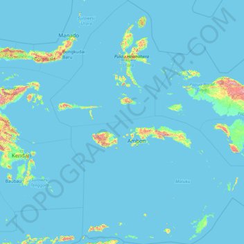
Name: Maluku topographic map, elevation, terrain.

Location: Maluku, Indonesia (-8.55226 123.92323 3.40760 135.58989)

Average elevation: 41 m

Minimum elevation: -1 m

Maximum elevation: 2,811 m

Other topographic maps

Click on a map to view its topography, its elevation and its terrain.

South Tangerang

Indonesia > Banten

Average elevation: 40 m

Ciater

Indonesia > South Tangerang

Average elevation: 48 m

Sulawesi

Indonesia

The lowland forests on the island have mostly been removed. Because of the relative geological youth of the island and its dramatic and sharp topography, the lowland areas are naturally limited in their extent. The past decade has seen dramatic conversion of this rare and endangered habitat. The island also…

Average elevation: 145 m

Special capital Region of Jakarta

Indonesia

Jakarta lies in a low and flat alluvial plain, ranging from −2 to 91 m (−7 to 299 ft) with an average elevation of 8 m (26 ft) above sea level with historically extensive swampy areas. Some parts of the city have been constructed on reclaimed tidal flats that occur around the area. Thirteen rivers flow…

Average elevation: 5 m

Cit

Indonesia > Bangka-Belitung Islands > Bangka

Average elevation: 19 m

Kelimutu

Indonesia > East Nusa Tenggara > Ende

Average elevation: 1,469 m

Karaka

Indonesia > West Papua

Average elevation: 60 m

Madiun

Indonesia > East Java

Average elevation: 278 m

Mount Talang

Indonesia > West Sumatra > Solok

Average elevation: 2,165 m

Biak Kota

Indonesia > Papua

Average elevation: 24 m

Bancea

Indonesia > Central Sulawesi

Average elevation: 1,051 m

Atuh Beach

Indonesia > Bali > Klungkung Regency > Wates

Average elevation: 54 m

Penanjakan

Indonesia > East Java > Pasuruan

Average elevation: 2,427 m

Pulau Dolak

Indonesia > South Papua

Average elevation: 3 m

Kawah Ijen Crater Lake

Indonesia > East Java > Bondowoso

Average elevation: 2,173 m

Papandayan

Indonesia > West Java > Garut

Average elevation: 2,319 m

Aruku

Indonesia > North Maluku > Halmahera Barat

Average elevation: 273 m

Sukabumi

Indonesia > West Java

At an altitude of approximately 584 m (1,916 ft), the city is a minor hill station resort, with a cooler climate than the surrounding lowlands. The area around Sukabumi is also a popular destination for whitewater rafting. Tea and Rubber production is a major industry in the area. The suburban area surrounding…

Average elevation: 570 m

Krakatoa

Indonesia > Lampung > Lampung Selatan

Average elevation: 20 m

Mount Marapi

Indonesia > West Sumatra > Agam

Average elevation: 2,457 m

Kerinci

Indonesia > Jambi

Average elevation: 947 m

Bali

Indonesia

Bali's central mountains include several peaks over 2,000 metres (6,600 feet) in elevation and active volcanoes such as Mount Batur. The highest is Mount Agung (3,031 m; 9,944 ft), known as the "mother mountain", which is an active volcano rated as one of the world's most likely sites for a massive eruption…

Average elevation: 88 m

Rantepao

Indonesia > South Sulawesi > Toraja Utara

Average elevation: 848 m

Malang

Indonesia > East Java > Kota Malang

The city was capital city of Singhasari in 1222, then transferred to Dutch colony. Malang was modernized under the Dutch; its mild climate which results from its elevation, along with its proximity to the major port of Surabaya, made it a popular destination for the Dutch and other Europeans. Malang began to…

Average elevation: 490 m

Cimahi City

Indonesia > West Java

Cimahi, located 180 km south east of Jakarta, is situated between Bandung and West Bandung Regency. Cimahi comprises three districts (kecamatan), which in turn are sub-divided into fifteen urban villages (kelurahan). Its lowest elevation is 685 metres (2,247 ft) above sea level and directs to Citarum River.…

Average elevation: 779 m

Bokondini

Indonesia > Highland Papua > Tolikara

Average elevation: 1,456 m

Medewi

Indonesia > Bali > Jembrana

Average elevation: 49 m

Ubud

Indonesia > Bali > Gianyar

Average elevation: 215 m

Manado

Indonesia > North Sulawesi

Average elevation: 62 m

Sungai Abang

Indonesia > Jambi > Batanghari > Rantau Kapas Tuo

Average elevation: 20 m

Java

Indonesia

Java is an island with a large amount of biodiversity. The natural environment of Java is tropical rainforest, with ecosystems ranging from coastal mangrove forest on the north coast, rocky coastal cliffs on the southern coast, and low-lying tropical forest to high altitude rainforest on the slopes of…

Average elevation: 39 m

Sumbawa

Indonesia > West Nusa Tenggara

Average elevation: 79 m

Lau Labi

Indonesia > North Sumatra > Deli Serdang > Cinta Rakyat

Average elevation: 903 m

East Nusa Tenggara

Indonesia

Average elevation: 31 m

Calaca

Indonesia > North Sulawesi > Manado

Average elevation: 11 m

Garut

Indonesia > West Java

The Garut Regency has two distinct topographical areas.

Average elevation: 708 m

Bandung

Indonesia > West Java

Bandung (Sundanese: ᮊᮧᮒ ᮘᮔ᮪ᮓᮥᮀ, romanized: Kota Bandung, pronounced [ˈbandʊŋ]; /ˈbɑːndʊŋ/) is the capital city of West Java province of Indonesia. Located on the island of Java, Greater Bandung (Bandung Basin Metropolitan Area / BBMA) is the country's second-largest and most populous…

Average elevation: 830 m

Boyolali

Indonesia > Central Java

Average elevation: 277 m

Wakatobi

Indonesia > Southeast Sulawesi

Average elevation: 4 m

Palangka Raya

Indonesia > Central Kalimantan

Palangka Raya borders Gunung Mas Regency to the north, Katingan Regency to the west, and Pulang Pisau Regency to the south and east. The area's soil consists mostly of peat and alluvium in its southern part and podzol on the northern part of the city. Overall, podzol soil dominates the city soil with 218,486…

Average elevation: 23 m

Makete

Indonesia > North Maluku > Halmahera Utara

Average elevation: 32 m