
Lake Wakatipu topographic map
Interactive map
Click on the map to display elevation.
Lake Wakatipu
With a length of 80 kilometres (50 mi), it is New Zealand's longest lake, and, at 289 km2 (112 sq mi), its third largest. The lake is also very deep, its floor being below sea level (−110 metres), with a maximum depth of 420 metres (1,380 ft). It is at an altitude of 310 metres (1,020 ft), towards the southern end of the Southern Alps / Kā Tiritiri o te Moana. The general topography is a reversed "N" shape or "dog leg". The Dart River / Te Awa Whakatipu flows into the northern end, the lake then runs south for 30 kilometres before turning abruptly to the east. Twenty kilometres (12.4 mi) further along, it turns sharply to the south, reaching its southern end 30 kilometres (19 mi) further south, near Kingston. At the north end of the lake is the settlement of Glenorchy, in the north-east corner, and the smaller isolated locality of Kinloch in the north-west corner.
About this map
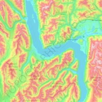
Name: Lake Wakatipu topographic map, elevation, terrain.
Average elevation: 952 m
Minimum elevation: 304 m
Maximum elevation: 2,265 m
Routes: Queenstown-Lakes District GPS tracks, routes, trails, hikes
Other topographic maps
Click on a map to view its topography, its elevation and its terrain.
Queenstown
New Zealand > Otago > Queenstown-Lakes District
The town is at a relatively low altitude for a ski and snowboarding centre, at 310 metres (1,020 ft) above sea level at the lake shore, but is nestled among mountains, most notably the scenic attraction of The Remarkables, to the town's southeast. Below the lake lies the deep Kawarau Gorge, and there are…
Average elevation: 592 m
Kelvin Peninsula
New Zealand > Otago > Queenstown-Lakes District > Queenstown
Average elevation: 372 m