
Make a donation
Vorarlberg topographic map
Click on the map to display elevation.
Make a donation
Vorarlberg
The highest mountain is the Piz Buin, whose rocky peak of 3,312 m (10,866 ft) is surrounded by glaciers. The distance from Lake Constance and the plains of the Alpine Rhine valley across the medium altitude and high Alpine zones to the glaciers of the Silvretta range is a mere 90 km (56 mi).
Make a donation
About this map
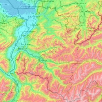
Name: Vorarlberg topographic map, elevation, terrain.
Location: Vorarlberg, Austria (46.84086 9.53075 47.59610 10.23716)
Average elevation: 1,382 m
Minimum elevation: 392 m
Maximum elevation: 3,386 m
Make a donation
Other topographic maps
Click on a map to view its topography, its elevation and its terrain.
Turracher Höhe
Austria > Carinthia > Reichenau
The highest point of the approx. two km long pass summit has an altitude of 1,795 m above sea level south of the Turracher Lake. The lake has a water level of 1,763 m above sea (Adria) level and is connected to the village. The Turracher Höhe, as a "classic" pass summit, is also part of a drainage divide…
Average elevation: 1,870 m
Make a donation
Make a donation
Make a donation
Leithaberg
Austria > Burgenland > Bezirk Eisenstadt-Umgebung > Gemeinde Schützen am Gebirge
Average elevation: 319 m
Make a donation
Graz
Austria > Styria > Graz > Graz
Graz is situated on both sides of the Mur river in southeast Austria. It is about 150 km (93 mi) southwest of Vienna (Wien). The nearest larger urban centre is Maribor (Marburg) in Slovenia, which is about 50 km (31 mi) to the south. Graz is the state capital and largest city in Styria, a green and heavily…
Average elevation: 482 m