
Make a donation
Transantarctic Mountains topographic map
Click on the map to display elevation.
Make a donation
Transantarctic Mountains
The first crossing of the Transantarctic Mountains took place during the 1902–1904 British National Antarctic Expedition at the Ross Ice Shelf. A reconnaissance party under the command of Albert Armitage reached 2,700 m (8,900 ft) altitude in 1902. The following year, a party under expedition leader Robert Falcon Scott crossed into East Antarctica at a location now known as Ferrar Glacier, named after the geologist of the expedition. They explored part of Victoria Land on the Antarctic Plateau before returning via the same glacier. In 1908, Ernest Shackleton's party crossed the mountains through the Beardmore Glacier. Scott returned to that same glacier in 1911, while Roald Amundsen crossed the range via the Axel Heiberg Glacier.
Make a donation
About this map
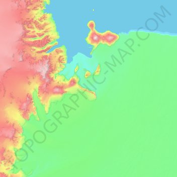
Name: Transantarctic Mountains topographic map, elevation, terrain.
Location: Transantarctic Mountains (-84.35005 166.49995 -84.34995 166.50005)
Average elevation: 378 m
Minimum elevation: 0 m
Maximum elevation: 3,958 m
Make a donation
Other topographic maps
Click on a map to view its topography, its elevation and its terrain.
Philippines
The Philippines is an archipelago of approximately 7,641 islands, with a total land area of about 300,000 square kilometers. The terrain is predominantly mountainous, with narrow coastal plains and valleys. The highest peak is Mount Apo on Mindanao, reaching 2,954 meters (9,692 feet) above sea level. Other…
Average elevation: 33 m
Las Vegas
United States > Nevada > Clark County
The peaks surrounding Las Vegas reach elevations of over 10,000 feet (3,000 m), and act as barriers to the strong flow of moisture from the surrounding area. The elevation is approximately 2,030 ft (620 m) above sea level. According to the United States Census Bureau, the city has a total area of 135.86 sq mi…
Average elevation: 756 m
England
England's topography is characterized by a diverse landscape that transitions from low-lying plains to rugged uplands. In the north and west, the terrain is dominated by mountain ranges such as the Pennines, often referred to as the "backbone of England," and the Lake District, which includes Scafell Pike, the…
Average elevation: 55 m
Make a donation
District of Columbia
The highest natural elevation in the District is 409 feet (125 m) above sea level at Fort Reno Park in upper northwest Washington. The lowest point is sea level at the Potomac River. The geographic center of Washington is near the intersection of 4th and L Streets NW.
Average elevation: 49 m
Metro Manila
The Coastal Margin or Lowland is a flat and low plain that faces Manila Bay. Located here is Manila, Navotas, parts of Malabon, and the western part and reclaimed areas of Pasay and Parañaque, where the ground elevation ranges from zero meters on Manila Bay to five meters at the west side of the cities of…
Average elevation: 43 m
Jerusalem
Jerusalem is situated on the southern spur of a plateau in the Judaean Mountains, which include the Mount of Olives (East) and Mount Scopus (North East). The elevation of the Old City is approximately 760 m (2,490 ft). The whole of Jerusalem is surrounded by valleys and dry riverbeds (wadis). The Kidron,…
Average elevation: 661 m
Tennessee
Tennessee features a diverse and varied topography characterized by its distinct regions, which include the Appalachian Mountains, the Central Basin, and the Gulf Coastal Plain. The state’s highest point is Clingmans Dome, rising to about 6,643 feet (2,025 meters) above sea level, while the lowest point is…
Average elevation: 233 m
Make a donation
Armonk
United States > New York > Westchester County > Armonk
Situated 11 miles from the coast in the southeastern corner of New York, Armonk shares a border with Connecticut. The landscape is hilly and forested with a mean elevation of 387 feet.
Average elevation: 155 m
Henderson
United States > Nevada > Clark County
Henderson is a city in Clark County, Nevada, United States, about 16 miles (26 km) southeast of downtown Las Vegas. It is the second largest city in Nevada, after Las Vegas, with an estimated population of 320,189 in 2019. The city is part of the Las Vegas Valley. Henderson occupies the southeastern end of the…
Average elevation: 688 m
Make a donation
Raleigh
United States > North Carolina > Wake County
Raleigh is located in the northeast central region of North Carolina, where the Piedmont and Atlantic coastal plain regions meet. This area is known as the "fall line" because it marks the elevation inland at which waterfalls begin to appear in creeks and rivers. As a result, most of Raleigh features gently…
Average elevation: 103 m
Warsaw
Warsaw lies in east-central Poland about 300 km (190 mi) from the Carpathian Mountains and about 260 km (160 mi) from the Baltic Sea, 523 km (325 mi) east of Berlin, Germany. The city straddles the Vistula River. It is located in the heartland of the Masovian Plain, and its average elevation is 100 m (330 ft)…
Average elevation: 96 m
Make a donation
Khartoum
Khartoum is relatively flat, at elevation 385 m (1,263 ft), as the Nile flows northeast past Omdurman to Shendi, at elevation 364 m (1,194 ft)about 101 miles (163 km) away.
Average elevation: 384 m
Make a donation
New Zealand
New Zealand (Māori: Aotearoa [aɔˈtɛaɾɔa]) is an island country in the southwestern Pacific Ocean. It consists of two main landmasses—the North Island (Te Ika-a-Māui) and the South Island (Te Waipounamu)—and over 700 smaller islands. It is the sixth-largest island country by area, covering 268,021…
Average elevation: 399 m
Make a donation
Hudson Bay
From the large quantity of published geologic data that has been collected as the result of hydrocarbon exploration, academic research, and related geological mapping, a detailed history of the Hudson Bay basin has been reconstructed. During the majority of the Cambrian Period, this basin did not exist.…
Average elevation: 35 m
Make a donation
Make a donation
Nashville
United States > Tennessee > Davidson County
Nashville lies on the Cumberland River in the northwestern portion of the Nashville Basin. Nashville's elevation ranges from its lowest point, 385 feet (117 m) above sea level at the Cumberland River, to its highest point, 1,163 feet (354 m) above sea level in the Radnor Lake State Natural Area. Nashville also…
Average elevation: 184 m
Make a donation
Biel/Bienne
Switzerland > Bern > Biel/Bienne administrative district
One funicular railways leads to the national sports center of Magglingen/Macolin on the 500 metres (1,600 ft) higher Jura mountain in the west, and the other, the Bienne-Evilard Funicular, to the city hospital and to neighbouring municipality Evilard to northwest, both above the town on the eastern range of…
Average elevation: 655 m
Make a donation
Grad Rovinj
Since records began in 1984, the highest temperature recorded at the Sveti Ivan na pučini weather station at an elevation of 8 metres (26 ft) was 34.2 °C (93.6 °F), on 5 August 2017. The coldest temperature was −6.5 °C (20.3 °F), on 29 December 1996.
Average elevation: 24 m
Make a donation
British Columbia
The Southern Interior cities of Kamloops and Penticton have some of the warmest and longest summer climates in Canada (while higher elevations are cold and snowy), although their temperatures are often exceeded north of the Fraser Canyon, close to the confluence of the Fraser and Thompson rivers, where the…
Average elevation: 708 m
South Chilcotin Mountains Provincial Park
Canada > British Columbia > Squamish-Lillooet Regional District
The park has many visually striking areas, such as mid elevation grasslands, sub alpine and alpine meadows, alpine lakes and mountain peaks, accompanied with complete watersheds. it is also full of trails through valleys, alpine meadows and ridges varying in difficulty to give the best wilderness experience.
Average elevation: 1,910 m
Make a donation
Make a donation
Iowa City
United States > Iowa > Johnson County
The elevation at the Iowa City Municipal Airport is 668 ft (203.6 m) above sea level.
Average elevation: 216 m
Make a donation
Make a donation
Madison County
The topography in the southern and eastern portions of the county is dominated by the dissected remnants of the Cumberland Plateau, such as Keel Mountain, Monte Sano Mountain and Green Mountain. The northern and western portions of the county are flatter.
Average elevation: 245 m
Make a donation
South Island
The South Island, also officially named Te Waipounamu, is the larger of the two major islands of New Zealand in surface area, the other being the smaller but more populous North Island. It is bordered to the north by Cook Strait, to the west by the Tasman Sea, and to the south and east by the Pacific Ocean.…
Average elevation: 201 m
Fiji
Average elevation: 386 m
Make a donation
Nakhon Nayok Province
The northern part of the province is in the Sankamphaeng Range, the southern prolongation of the Dong Phaya Yen Mountains, with the highest elevation the 1,292-meter-high Yod Khao Kiew. Most of that area is covered by the Khao Yai National Park, 2,166 km2 (836 sq mi), along with three other national parks,…
Average elevation: 185 m
Theni
The economy of Theni district is mostly agricultural. Utilization of land area for cultivation in the district is 40.33%. The principal crops produced (in tonnes) in 2005-2006 were sugarcane 1,201,221, cotton 95,360 (561 bales of 170. kg lint each), rice (paddy) 66,093, millets and other cereals 57,081, pulses…
Average elevation: 735 m
Make a donation
Az Za'ayyem Bedouins
Palestinian Territories > Judea and Samaria > Area C > 'Anata
Average elevation: 603 m
Make a donation
Massachusetts
Despite its small size, Massachusetts features numerous topographically distinctive regions. The large coastal plain of the Atlantic Ocean in the eastern section of the state contains Greater Boston, along with most of the state's population, as well as the distinctive Cape Cod peninsula. To the west lies the…
Average elevation: 128 m
Make a donation
Jilin
Jilin is highest in altitude in the southeast and drops gently towards the northwest. The Changbai Mountains run through its southeastern regions and contains the highest peak of the province, Paektu Mountain at 2,744 m (9,003 ft). Other ranges include the Jilinhada Mountains, Zhang Guangcai Mountains, and…
Average elevation: 352 m
Make a donation
Mishor Adumim
Palestinian Territories > Judea and Samaria > Area C > Maale Adumim
Average elevation: 265 m
Make a donation
Mitchell
United States > Oregon > Wheeler County
The business district, including the saloons, grew up along Bridge Creek and became known locally as "Tiger Town". The church and most of the city's homes were built at higher elevation on a bench overlooking the creek; this part of town was known locally as "Piety Hill". About half the town was destroyed by…
Average elevation: 959 m
Make a donation
Schneeberg
Austria > Lower Austria > Bezirk Neunkirchen > Schwarzau im Gebirge
A rack-and-pinion railway, the Schneeberg Railway, now over 100 years old, climbs to a height of 1,800 m (5,900 ft), reducing the walk to the summit to an hour or two. There are also a number of other routes for walkers, including from the spa resort of Puchberg am Schneeberg to the east, or from the south, in…
Average elevation: 1,081 m
Urbino
Italy > Marche > Pesaro e Urbino
The century began quietly. In addition to the artistic development from the Scuola del Libro, Urbino also began to grow as a university town, with the elevation to university faculty of nineteenth-century School of Pharmacy and the birth of the department of Education (approximately 1934). Due to these changes…
Average elevation: 301 m
Make a donation
Make a donation