
Christchurch City topographic map
Interactive map
Click on the map to display elevation.
About this map
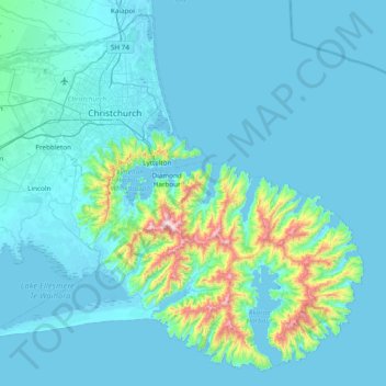
Name: Christchurch City topographic map, elevation, terrain.
Location: Christchurch City, Canterbury, New Zealand (-43.90235 172.36374 -43.38989 173.13140)
Average elevation: 74 m
Minimum elevation: -3 m
Maximum elevation: 904 m
Other topographic maps
Click on a map to view its topography, its elevation and its terrain.
Christchurch
New Zealand > Canterbury > Christchurch City
Christchurch, Christchurch City, Canterbury, New Zealand
Average elevation: 41 m
Timaru
New Zealand > Canterbury > Timaru District
Timaru, Timaru District, Canterbury, 7910, New Zealand
Average elevation: 16 m
Ashburton
New Zealand > Canterbury > Ashburton District
Ashburton, Ashburton District, Canterbury, 7700, New Zealand
Average elevation: 99 m
Port hills
New Zealand > Canterbury > Christchurch City > Linwood-Central-Heathcote Community
Port hills, Greenwood Park Mountain Bike Track, Linwood-Central-Heathcote Community, Christchurch City, Canterbury, 8082, New Zealand
Average elevation: 246 m
Hanmer Springs
New Zealand > Canterbury > Hurunui District
Hanmer Springs, Hurunui District, Canterbury, 7334, New Zealand
Average elevation: 490 m
Rangiora
New Zealand > Canterbury > Waimakariri District
Rangiora, Waimakariri District, Canterbury, 7400, New Zealand
Average elevation: 31 m
Lake Hood
New Zealand > Canterbury > Ashburton District
Lake Hood, Ashburton District, Canterbury, New Zealand
Average elevation: 64 m
Loburn
New Zealand > Canterbury > Waimakariri District
Loburn, Waimakariri District, Canterbury, 7472, New Zealand
Average elevation: 110 m
Ashley
New Zealand > Canterbury > Waimakariri District
Ashley, Waimakariri District, Canterbury, 7400, New Zealand
Average elevation: 43 m
Rakaia
New Zealand > Canterbury > Ashburton District
Rakaia, Ashburton District, Canterbury, 7710, New Zealand
Average elevation: 105 m
Lees Valley
New Zealand > Canterbury > Waimakariri District
Lees Valley, Waimakariri District, Canterbury, New Zealand
Average elevation: 423 m
Fairview
New Zealand > Canterbury > Timaru District
Fairview, Timaru District, Canterbury, 7910, New Zealand
Average elevation: 57 m
Banks Peninsula
New Zealand > Canterbury > Christchurch City > Banks Peninsula Community > Pigeon Bay
Banks Peninsula, Pigeon Bay, Banks Peninsula Community, Christchurch City, Canterbury, 7581, New Zealand
Average elevation: 277 m
Windwhistle
New Zealand > Canterbury > Selwyn District
Windwhistle, Selwyn District, Canterbury, New Zealand
Average elevation: 434 m
Springfield
New Zealand > Canterbury > Selwyn District
Springfield, Selwyn District, Canterbury, 7649, New Zealand
Average elevation: 396 m
Birdlings Flat
New Zealand > Canterbury > Christchurch City > Banks Peninsula Community
Birdlings Flat, Banks Peninsula Community, Christchurch City, Canterbury, New Zealand
Average elevation: 15 m
Prebbleton
New Zealand > Canterbury > Selwyn District
Prebbleton, Selwyn District, Canterbury, 7604, New Zealand
Average elevation: 25 m
Duvauchelle
New Zealand > Canterbury > Christchurch City > Banks Peninsula Community
Duvauchelle, Banks Peninsula Community, Christchurch City, Canterbury, 7581, New Zealand
Average elevation: 277 m
Twizel
New Zealand > Canterbury > Mackenzie District
Twizel, Mackenzie District, Canterbury, 7901, New Zealand
Average elevation: 472 m
Kaikoura
New Zealand > Canterbury > Kaikoura
Kaikoura, Kaikōura District, Canterbury, 7300, New Zealand
Average elevation: 15 m
Akaroa
New Zealand > Canterbury > Christchurch City > Banks Peninsula Community
Akaroa, Banks Peninsula Community, Christchurch City, Canterbury, New Zealand
Average elevation: 152 m
Mandeville North
New Zealand > Canterbury > Waimakariri District
Mandeville North, Waimakariri District, Canterbury, 7692, New Zealand
Average elevation: 33 m
Ōtūroto / Lake Heron
New Zealand > Canterbury > Ashburton District
Ōtūroto / Lake Heron, Ashburton District, Canterbury, New Zealand
Average elevation: 750 m
Rolleston
New Zealand > Canterbury > Selwyn District
Rolleston, Selwyn District, Canterbury, 7643, New Zealand
Average elevation: 54 m
Lindis Pass
New Zealand > Canterbury > Waitaki District
Lindis Pass, Waitaki District, Canterbury, New Zealand
Average elevation: 1,011 m
Mount Fyffe
New Zealand > Canterbury > Kaikoura
Mount Fyffe, Kaikōura, Canterbury, New Zealand
Average elevation: 1,142 m
Pegasus
New Zealand > Canterbury > Waimakariri District
Pegasus, Waimakariri District, Canterbury, New Zealand
Average elevation: 5 m
Kaiapoi
New Zealand > Canterbury > Waimakariri District
Kaiapoi, Waimakariri District, Canterbury, 7630, New Zealand
Average elevation: 5 m
Mount Blackburn
New Zealand > Canterbury > Mackenzie District
Mount Blackburn, Mackenzie District, Canterbury, New Zealand
Average elevation: 1,634 m
Castle Hill Village
New Zealand > Canterbury > Selwyn District
Castle Hill Village, Selwyn District, Canterbury, 7580, New Zealand
Average elevation: 787 m
Lake Tekapo
New Zealand > Canterbury > Mackenzie District
Lake Tekapo, Mackenzie District, Canterbury, New Zealand
Average elevation: 743 m
Okains Bay
New Zealand > Canterbury > Christchurch City > Banks Peninsula Community
Okains Bay, Banks Peninsula Community, Christchurch City, Canterbury, 7853, New Zealand
Average elevation: 148 m
Banks Peninsula Community
New Zealand > Canterbury > Christchurch City
Banks Peninsula Community, Christchurch City, Canterbury, New Zealand
Average elevation: 70 m
Totara Peak
New Zealand > Canterbury > Ashburton District
Totara Peak, Ashburton District, Canterbury, New Zealand
Average elevation: 1,645 m
Southern Alps
Southern Alps, Mackenzie District, Canterbury, New Zealand
Average elevation: 2,832 m
New Brighton
New Zealand > Canterbury > Christchurch
New Brighton, Christchurch, Canterbury, New Zealand
Average elevation: 3 m
Le Bons Bay
New Zealand > Canterbury > Christchurch City > Banks Peninsula Community
Le Bons Bay, Banks Peninsula Community, Christchurch City, Canterbury, 7583, New Zealand
Average elevation: 244 m
Giant Totara tree
New Zealand > Canterbury > Christchurch City > Banks Peninsula Community
Giant Totara tree, Te Ara Pātaka / Summit Walkway, Little River, Banks Peninsula Community, Christchurch City, Canterbury, New Zealand
Average elevation: 382 m
Okuku Hill
New Zealand > Canterbury > Waimakariri District
Okuku Hill, Waimakariri District, Canterbury, New Zealand
Average elevation: 872 m
Rakaia Gorge lookout
New Zealand > Canterbury > Ashburton District
Rakaia Gorge lookout, Arundel Rakaia Gorge Road, Ashburton District, Canterbury, New Zealand
Average elevation: 358 m
Selwyn District
Selwyn District, Canterbury, New Zealand
Average elevation: 679 m
Governors Bay
New Zealand > Canterbury > Christchurch City > Banks Peninsula Community
Governors Bay, Banks Peninsula Community, Christchurch City, Canterbury, 8971, New Zealand
Average elevation: 167 m
Lincoln
New Zealand > Canterbury > Selwyn District
Lincoln, Selwyn District, Canterbury, 7608, New Zealand
Average elevation: 15 m
Pegasus
New Zealand > Canterbury > Pegasus
Pegasus, Waimakariri District, Canterbury, 7612, New Zealand
Average elevation: 6 m
Wainui
New Zealand > Canterbury > Christchurch City > Banks Peninsula Community
Wainui, Banks Peninsula Community, Christchurch City, Canterbury, 7582, New Zealand
Average elevation: 203 m
Dromore
New Zealand > Canterbury > Ashburton District
Dromore, Ashburton District, Canterbury, 7772, New Zealand
Average elevation: 123 m
Methven
New Zealand > Canterbury > Ashburton District
Methven, Ashburton District, Canterbury, 7730, New Zealand
Average elevation: 322 m
Waimakariri District
Waimakariri District, Canterbury, New Zealand
Average elevation: 476 m
Sheffield
New Zealand > Canterbury > Selwyn District
Sheffield, Selwyn District, Canterbury, 7500, New Zealand
Average elevation: 309 m
Mount Lyford
New Zealand > Canterbury > Hurunui District
Mount Lyford, Hurunui District, Canterbury, New Zealand
Average elevation: 1,242 m