Geolocate

Maruia River topographic map

Interactive map

Click on the map to display elevation.

About this map

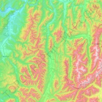
Name: Maruia River topographic map, elevation, terrain.

Location: Maruia River, Tasman, 7062, New Zealand (-42.38017 172.18133 -41.78585 172.36760)

Average elevation: 760 m

Minimum elevation: 33 m

Maximum elevation: 2,224 m

Tasman trails, hiking, mountain biking, running and outdoor activities

Other topographic maps

Click on a map to view its topography, its elevation and its terrain.

Mount Murchison

New Zealand > Tasman > Tasman District

Average elevation: 1,124 m

Dovedale

New Zealand > Tasman

Average elevation: 296 m

Richmond Hill

New Zealand > Tasman > Tasman District

Average elevation: 322 m

Brightwater

New Zealand > Tasman

Average elevation: 73 m

Lake Rotoiti

New Zealand > Tasman > Saint Arnaud

Average elevation: 1,031 m

Wakefield

New Zealand > Tasman

Average elevation: 134 m

Golden Bay

New Zealand > Tasman > Tasman District

Average elevation: 43 m

Upper Moutere

New Zealand > Tasman

Average elevation: 97 m

Nelson Lakes National Park

New Zealand > Tasman

Average elevation: 1,098 m

Tākaka

New Zealand > Tasman

Average elevation: 50 m

Tākaka Hill

New Zealand > Tasman

Average elevation: 649 m

Ruby Bay

New Zealand > Tasman

Average elevation: 23 m

Golden Downs

New Zealand > Tasman

Average elevation: 388 m

Redwood Valley

New Zealand > Tasman

Average elevation: 46 m

Mapua

New Zealand > Tasman

Average elevation: 23 m

Collingwood

New Zealand > Tasman > Collingwood

Average elevation: 13 m

Riwaka

New Zealand > Tasman

Average elevation: 10 m

Totaranui

New Zealand > Tasman > Totaranui

Average elevation: 82 m

Tonga Island

New Zealand > Tasman

Average elevation: 9 m

Abel Tasman

New Zealand > Tasman > Torrent Bay

Average elevation: 14 m

Mole Tops

New Zealand > Tasman

Average elevation: 1,414 m