
Make a donation
North Island topographic map
Click on the map to display elevation.
Make a donation
About this map
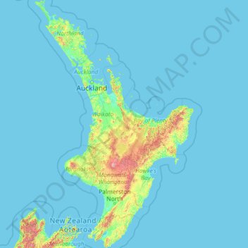
Name: North Island topographic map, elevation, terrain.
Location: North Island, New Zealand (-41.61375 172.64302 -34.39339 178.55050)
Average elevation: 66 m
Minimum elevation: -1 m
Maximum elevation: 2,650 m
New Zealand trails, hiking, mountain biking, running and outdoor activities
Make a donation
Other topographic maps
Click on a map to view its topography, its elevation and its terrain.
Auckland
Auckland’s topography is uniquely shaped by its position on a narrow, undulating isthmus between the Waitematā Harbour to the north and the Manukau Harbour to the south, creating a landscape defined by low coastal plains interrupted by abrupt volcanic relief. The city stands atop the Auckland Volcanic…
Average elevation: 32 m
Queenstown
New Zealand > Otago > Queenstown-Lakes District
The town is at a relatively low altitude for a ski and snowboarding centre, at 310 metres (1,020 ft) above sea level at the lake shore, but is nestled among mountains, most notably the scenic attraction of The Remarkables, to the town's southeast. Below the lake lies the deep Kawarau Gorge, and there are…
Average elevation: 592 m
Wellington
New Zealand > Wellington > Wellington City
Averaging 2,055 hours of sunshine per year, the climate of Wellington is temperate marine, (Köppen: Cfb), generally moderate all year round with warm summers and mild winters, and rarely sees temperatures above 23 °C (73 °F) or below 4 °C (39 °F). The hottest recorded temperature in the city is 31.1 °C…
Average elevation: 85 m
Make a donation
Dunedin
New Zealand > Otago > Dunedin City
The climate of Dunedin in general is temperate. The city is recognised as having a large number of microclimates and the weather conditions often vary between suburbs mostly due to the city's topographical layout. Under the Köppen climate classification, Dunedin features an oceanic climate. The city's climate…
Average elevation: 110 m
Make a donation
Make a donation
Make a donation
Make a donation
Make a donation
Make a donation
Make a donation
Tautoro
New Zealand > Northland > Far North District > Kaikohe-Hokianga Community
Average elevation: 136 m
Make a donation
Make a donation
Make a donation
Make a donation
Make a donation
Pembroke Glacier
New Zealand > Southland > Southland District > Fiordland Community
Average elevation: 1,211 m
Make a donation
Make a donation
Auckland Domain
New Zealand > Auckland > Auckland
During the 2023 Auckland Anniversary Weekend floods, a lake reformed in the lower elevation area of Pukekawa / Auckland Domain that was once a wetland.
Average elevation: 49 m
Spenser Mountains
New Zealand > Tasman > Hurunui District
The Spenser Mountains is a topographic landform in the northern South Island of New Zealand. Located at the southern end of the Nelson Lakes National Park and north of the Lewis Pass they form a natural border between the Canterbury and Tasman regions. Several peaks are named after characters in Edmund…
Average elevation: 1,310 m
Make a donation
Naseby
New Zealand > Otago > Central Otago District > Maniototo Community
Naseby is a small town in the Maniototo region of Central Otago, New Zealand. The town catch phrase is "2000 feet above worry level" indicating its altitude. The town is 140 km (90 mi) from Dunedin. The centre of the town is a registered historic area, and there are many heritage buildings. Naseby has hot…
Average elevation: 619 m
Make a donation
Make a donation
Make a donation
Make a donation
Make a donation
Hanmer Springs
New Zealand > Hurunui District
The Jacks Pass – Clarence River – Jollies Pass Loop is a 25 kilometer loop which is not technically challenging however it takes between two to four hours to complete. It can be ridden in either direction: West over Jacks Pass (869m) or East over Jollies Pass (850m). As the entire ride is at high elevation…
Average elevation: 490 m
Make a donation
Purerua Peninsula
New Zealand > Northland > Far North District > Bay of Islands
Average elevation: 34 m
Make a donation
Pauri Village
New Zealand > Manawatu-Whanganui > Whanganui District > Whanganui
Average elevation: 50 m
Featherston
New Zealand > Wellington > South Wairarapa District > Featherston Community
Average elevation: 125 m
Make a donation
Punaromia
New Zealand > Bay of Plenty > Rotorua Lakes District > Lake Tarawera
Average elevation: 443 m
Make a donation