
Ballara topographic map
Interactive map
Click on the map to display elevation.
About this map
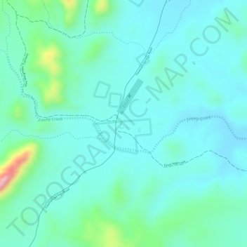
Name: Ballara topographic map, elevation, terrain.
Location: Ballara, Queensland, Australia (-20.95574 139.95384 -20.93574 139.97384)
Average elevation: 406 m
Minimum elevation: 369 m
Maximum elevation: 546 m
Other topographic maps
Click on a map to view its topography, its elevation and its terrain.
Edmonton
Australia > Queensland > Edmonton
The average elevation of Edmonton, Cairns is 16.8 metres (55.1 feet) above sea level.
Average elevation: 96 m
Roma
Roma experiences a humid subtropical climate (Köppen: Cfa, Trewartha: Cfal); with hot summers with moderate rains; warm to hot, relatively dry springs and autumns; and mild, dry winters. Its location on the far south of the Carnarvon Range at an elevation of 299 metres above sea level means that it is cooler…
Average elevation: 315 m
Koala Park Bushland Conservation Reserve
Australia > Queensland > Sunshine Coast Regional > Nambour
Average elevation: 35 m